Millwall Dock
Millwall Dock is a dock at Millwall, London, England, located south of Canary Wharf on the Isle of Dogs.
History
The Millwall Dock was constructed by John Aird & Co. to a design by Sir John Fowler and opened in 1868.[1]
The dock is L-shaped, with an 'Outer Dock' running east-west, and an 'Inner Dock' running north from the eastern end. It originally contained around 36 acres (14 hectares) of water and had a 200-acre (81 hectare) estate. The western end of the Outer Dock was originally connected to the Thames at Millwall by an 80 ft (24 m) wide channel. The spoil from the docks formed the area of wasteland known as the Mudchute. A graving dock for ship repairs was constructed at the SE corner of the Outer Dock (one of 6 originally planned), and later lengthened to 555 ft (169 m).
From 1905 Magnus Mowat worked as Engineer to the docks, being promoted to Director around 1912.[2]
With reorganisation by the Port of London Authority in the 1920s, the northern end of the Inner Dock was connected to the West India Docks by the Millwall Passage, and the direct connection to the Thames was filled.
The dock was used mainly for timber and grain, a trade which eventually moved down river to the Port of Tilbury with the construction of a major grain terminal in the 1960s. A McDougall's flour mill, the Wheatsheaf Mill (constructed in 1869), stood on the south side of the Outer Dock, but was demolished in about 1980. Nearby Sir John McDougall Gardens is named after one of the McDougall brothers, John McDougall, who was also a prominent local politician in Poplar.[3]
The area today
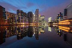
Millwall Dock lies near the centre of the Isle of Dogs, just south of the now developed Canary Wharf commercial business area.
A large site on the north side of Outer Dock is occupied by the West Ferry Printing Works, the largest newspaper print works in Western Europe,[4] built 1984–6. Millwall Dock is a commercial business district that includes office towers housing small to medium-sized technology, publishing, legal and financial services companies.
Millwall Dock is also an area where several housing developments and impressive apartment towers have been developed. The Clippers Quay housing estate is located around the old dry dock, while the Mill Quay housing development is located on the site of the old flour mill. There is a marked contrast between the newly established living and working areas and the older neighbouring developments in the area.
Docklands Sailing and Watersports Centre is located at the far West end of the dock where the dock previously connected to the Thames.[5] It was set up in 1989 by the London Docklands Development Corporation and the Sports Council at a cost of £1.2 million.[6]
The dock was a location for boat stunts in the 1999 James Bond film The World Is Not Enough.
There are three Docklands Light Railway stations serving the Millwall Dock: Mudchute, Crossharbour and South Quay.
References
- ↑ British History on line
- ↑ https://www.gracesguide.co.uk/Magnus_Mowat
- ↑ "Sir John McDougall Gardens". London Gardens Trust. Retrieved 16 July 2016.
- ↑ Times Online, 15 February 2004, Desmond's double whammy, says "Westferry is the biggest printing works in western Europe."
- ↑ "Docklands Sailing and Watersports Centre". www.timeout.com. Time Out. 30 April 2005. Retrieved 3 December 2013.
- ↑ Hyde, John (27 August 2008). "Beijing success brings boost to sailing centre". London: www.edp24.co.uk. Archived from the original on 12 December 2013. Retrieved 3 December 2013.
Other sources
- "'The Millwall Docks: The docks'". Survey Survey of London: volumes 43 and 44: Poplar, Blackwall and Isle of Dogs (1994), pp. 353-356. English Heritage. Retrieved 2007-10-17.
- 'Dockland: An illustrated historical survey of life and work in east London', NELP/GLC, 1983, ISBN 0-7168-1611-3
External links
Coordinates: 51°29′43.37″N 0°0′58″W / 51.4953806°N 0.01611°W