Millswood, South Australia
| Millswood Adelaide, South Australia | |||||||||||||||
|---|---|---|---|---|---|---|---|---|---|---|---|---|---|---|---|
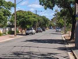 Millswood Crescent, looking towards the south-west | |||||||||||||||
| Population |
2,079 (2006 census)[1] 1,843 (2001 Census)[2] | ||||||||||||||
| Postcode(s) | 5034 | ||||||||||||||
| LGA(s) | City of Unley | ||||||||||||||
| State electorate(s) | |||||||||||||||
| Federal Division(s) | Adelaide | ||||||||||||||
| |||||||||||||||
Millswood is an inner-southern suburb of Adelaide in the City of Unley. It is dissected by Goodwood Road, which travels north to the Adelaide city centre from the southern suburb of Pasadena. On the west side of Goodwood Road it is surrounded by the suburbs of Goodwood, Forestville, Black Forest and Clarence Park. On the east side of Goodwood Road it is surrounded by the suburbs of Goodwood, Hyde Park, Unley Park and Kings Park.
At the northern edge of the west side of the suburb, the Adelaide-Goodwood railway line forks with the Seaford railway line going south-west and the Belair railway line going south-east. Within the triangle formed by the fork and Millswood Crescent are the SASMEE Park[3] and the Millswood croquet, bowls and lawn tennis clubs.
The Goodwood Oval and grandstand, with playground, barbeque facilities, soccer pitch and grandstand, cricket practise nets, and eight hard tennis courts, are located to the west of the fork in the railway line.
The former Goodwood Orphanage and the surrounding Orphanage Park are located on the south-east corner of Goodwood Road and Mitchell Street and now houses Tabor College Australia.[4]
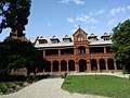 The former Goodwood Orphanage
.jpg) Goodwood Oval Grandstand
Goodwood Oval Grandstand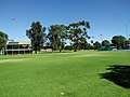 Goodwood Oval
Millswood had its own railway station on the Belair line on the southern edge of the suburb, but this was closed in the 1990s. It was reopened in 2014.[5] Goodwood Road passes under the railway line in a deep underpass, known as the Goodwood Subway, which often floods during heavy rain.
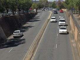 Goodwood Subway - from the railway bridge
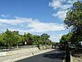 Goodwood Subway - from Goodwood Road
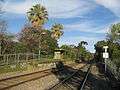 (Closed) Millswood Railway station in 2008
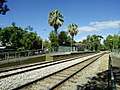 Millswood Railway station in 2018
References
- ↑ Australian Bureau of Statistics (25 October 2007). "Millswood (State Suburb)". 2006 Census QuickStats. Retrieved 19 July 2008.
- ↑ Australian Bureau of Statistics (9 March 2006). "Millswood (State Suburb)". 2001 Census QuickStats. Retrieved 17 July 2010.
- ↑ SASMEE - The South Australian Society of Model & Experimental Engineers, www.sasmee.com.au
- ↑ History, www.goodwoodroad.com.au
- ↑ http://www.adelaidenow.com.au/messenger/east-hills/millswood-train-station-is-set-to-remain-open-permanently-after-a-successful-year-long-trial/story-fni9lkyu-1227571788017?sv=e2ad48e8c777ce77b47c4e544171bb17&nk=73c2ac11b20cf2a1fcda6c99c42553b4-1466231686