Millerville, Alabama
| Millerville, Alabama | |
|---|---|
| Census-designated place | |
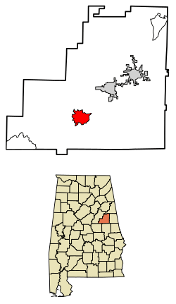 Location of Millerville in Clay County, Alabama. | |
 Millerville Location of Millerville in Clay County, Alabama. | |
| Coordinates: 33°11′29″N 85°55′33″W / 33.19139°N 85.92583°WCoordinates: 33°11′29″N 85°55′33″W / 33.19139°N 85.92583°W | |
| Country | United States |
| State | Alabama |
| County | Clay |
| Area[1] | |
| • Total | 6.72 sq mi (17.41 km2) |
| • Land | 6.70 sq mi (17.35 km2) |
| • Water | 0.02 sq mi (0.06 km2) |
| Elevation | 856 ft (261 m) |
| Population (2010)[2] | |
| • Total | 14,640 |
| • Estimate (2016)[3] | N/A |
| Time zone | UTC-6 (Central (CST)) |
| • Summer (DST) | UTC-5 (CDT) |
| Area code(s) | 256 & 938 |
| GNIS feature ID | 160110[4] |
Millerville is a census-designated place and unincorporated community in Clay County, Alabama, United States. Its population was 278 as of the 2010 census.[5]
Demographics
| Historical population | |||
|---|---|---|---|
| Census | Pop. | %± | |
| U.S. Decennial Census[6] | |||
References
- ↑ "2016 U.S. Gazetteer Files". United States Census Bureau. Retrieved Jul 17, 2017.
- ↑ "American FactFinder". United States Census Bureau. Retrieved 2011-05-14.
- ↑ "Population and Housing Unit Estimates". Retrieved June 9, 2017.
- ↑ "Millerville". Geographic Names Information System. United States Geological Survey.
- ↑ "Geographic Identifiers: 2010 Demographic Profile Data (G001): Millerville CDP, Alabama". U.S. Census Bureau, American Factfinder. Retrieved June 6, 2014.
- ↑ "Census of Population and Housing". Census.gov. Retrieved June 4, 2016.
Municipalities and communities of Clay County, Alabama, United States | ||
|---|---|---|
| City | 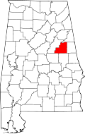 | |
| Town | ||
| CDPs | ||
| Unincorporated communities | ||
This article is issued from
Wikipedia.
The text is licensed under Creative Commons - Attribution - Sharealike.
Additional terms may apply for the media files.