Millers Dale railway station
| Millers Dale | |
|---|---|
 | |
| Location | |
| Area | High Peak |
| Coordinates | 53°15′23″N 1°47′36″W / 53.2563°N 1.7932°WCoordinates: 53°15′23″N 1°47′36″W / 53.2563°N 1.7932°W |
| Grid reference | SK135733 |
| Operations | |
| Pre-grouping | Midland Railway |
| Post-grouping | London, Midland and Scottish Railway |
| Platforms | 3 |
| History | |
| 1 June 1863 | Station opened |
| 1 May 1889 | renamed Millers Dale for Tideswell |
| 14 June 1965 | renamed Millers Dale |
| 6 March 1967 | Station closed[1] |
| Disused railway stations in the United Kingdom | |
|
Closed railway stations in Britain A B C D–F G H–J K–L M–O P–R S T–V W–Z | |
|
| |
| Monsal Trail | |||||||||||||||||||||||||||||||||||||||||||||||||||||||||||||||||||||||||||||||||||||||||||||||||||||||||||||||||||||||
|---|---|---|---|---|---|---|---|---|---|---|---|---|---|---|---|---|---|---|---|---|---|---|---|---|---|---|---|---|---|---|---|---|---|---|---|---|---|---|---|---|---|---|---|---|---|---|---|---|---|---|---|---|---|---|---|---|---|---|---|---|---|---|---|---|---|---|---|---|---|---|---|---|---|---|---|---|---|---|---|---|---|---|---|---|---|---|---|---|---|---|---|---|---|---|---|---|---|---|---|---|---|---|---|---|---|---|---|---|---|---|---|---|---|---|---|---|---|---|---|
| |||||||||||||||||||||||||||||||||||||||||||||||||||||||||||||||||||||||||||||||||||||||||||||||||||||||||||||||||||||||
Millers Dale railway station was situated in Millers Dale in the Peak District. It was built in 1863 by the Midland Railway on its extension of the Manchester, Buxton, Matlock and Midlands Junction Railway from Rowsley.
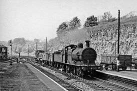
It served an important junction where passengers for Buxton joined or left the trains between London and Manchester. It was originally to be called "Blackwell Mill" but, in the end, was named "Millers Dale for Tideswell". For such a rural location, it was unusually large; indeed, it was one of the largest stations on the line, and was one of the few stations in England to have a post office on the platform. Millers Dale also sent dairy, agricultural and quarried products from the surrounding areas to the major cities. While also serving local towns and villages—notably Tideswell, Taddington and Wormhill—much of its activity was concerned with the connecting service to and from Buxton. Traffic for Buxton actually followed the main line north for nearly two miles, before diverging at Millers Dale Junction, beside Blackwell Mill Halt.[4]
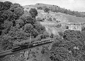
Built on a shelf carved out of the hillside, Millers Dale station originally had two platforms, but a bay platform was added in 1905 to accommodate Buxton trains, plus the down platform became an island platform to serve the extra tracks. The new loop and the second (northerly) viaduct were opened on 20 August 1905. The old viaduct was then closed, strengthened and reopened in April 1906.[5] Whilst the piers for the two viaducts are identical, the older viaduct is supported by an arch structure, whereas the later one is a box structure.
Part of the original Parliamentary Act approving the line considered the needs of invalids taking the waters at Buxton, and so, for a while, 'through' carriages for Buxton were attached to, and detached from, expresses, thus alleviating the problem of changing trains. In addition, the two main platforms were connected by a subway.
Changing at Millers Dale often involved a wait, and the High Peak News of November 1900 referred to the station as "Patience Junction".[4] The station was later immortalized in the 1964 song "Slow Train" by Flanders and Swann.[6]
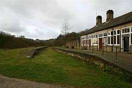
The station closed in 1967 but trains continued to pass through the station until 1968 when the line was closed. Since the railway was closed the station has become a car park serving the Monsal Trail, although the main buildings remain, being partly used as public toilets. The hamlet of Millers Dale is still dominated by the two large disused viaducts over the Wye valley. The older of the viaducts today forms part of the Monsal Trail, an 8.5-mile (13.7 km) walking and cycle track.
Route
| Preceding station | Disused railways | Following station | ||
|---|---|---|---|---|
| Peak Forest Line and station closed |
Midland Railway New Mills-Millers Dale line |
Monsal Dale Line and station closed | ||
| Blackwell Mill Line and station closed |
Midland Railway Manchester, Buxton, Matlock and Midland Junction Railway |
|||
To the north of the station, the line crossed the Wye three times and ran through the 401 yards (367 m) and 94 yards (86 m) Chee Tunnels and the 121 yards (111 m) Rusher Hall tunnel, before reaching the New Mills line junction, 1.25 miles (2.01 km) from the station.[5]
See also
References
- ↑ Butt, R.V.J., (1995) The Directory of Railway Stations, Yeovil: Patrick Stephens
- ↑ "Monsal Trail Derbyshire Peak District Litton Cressbrook Mill Cycling Bike Track Disused Railway". Retrieved 2009-04-21.
- ↑ "Monsal Trail structures". Retrieved 2010-04-17.
- 1 2 Railways of the Peak District. Blakemore & Mosley. 2003. ISBN 1-902827-09-0.
- 1 2 Railway Magazine October 1963 p. 680
- ↑ Lyrics to "Slow Train" Archived 13 April 2013 at the Wayback Machine.
| Wikimedia Commons has media related to Millers Dale railway station. |