Migojnice
| Migojnice | |
|---|---|
| Village | |
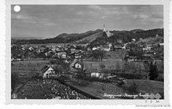 Postcard of Migojnice | |
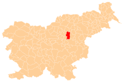
 Migojnice Location in Slovenia | |
| Coordinates: 46°13′45.56″N 15°9′31.27″E / 46.2293222°N 15.1586861°ECoordinates: 46°13′45.56″N 15°9′31.27″E / 46.2293222°N 15.1586861°E | |
| Country |
|
| Traditional region | Styria |
| Statistical region | Savinja |
| Municipality | Žalec |
| Area | |
| • Total | 2.57 km2 (0.99 sq mi) |
| Elevation | 288.7 m (947.2 ft) |
| Population (2002) | |
| • Total | 629 |
| [1] | |
Migojnice (pronounced [miˈɡoːi̯nitsɛ]) is a village on the right bank of the Savinja River in the Municipality of Žalec in east-central Slovenia. The area is part of the traditional region of Styria. The municipality is now included in the Savinja Statistical Region.[2]
Name
The village was attested in written sources in 1265–67 as Makoyn, and in 1763–87 as Megoiniz. The origin of the name is unclear, but it may be derived from *Maligojnice (based on the personal name *Maligojь) with syncope of the second syllable (cf. Magozd < *Mal(i) gozd). If so, the name would originally mean 'place where Maligojь's people live'.[3]
Church
The local church is dedicated to Our Lady of Lourdes (Slovene: Lurška Mati božja) and belongs to the Parish of Griže. It was built between 1888 and 1891.[4]
References
- ↑ Statistical Office of the Republic of Slovenia
- ↑ Žalec municipal site
- ↑ Snoj, Marko. 2009. Etimološki slovar slovenskih zemljepisnih imen. Ljubljana: Modrijan and Založba ZRC, p. 262.
- ↑ Slovenian Ministry of Culture register of national heritage reference number ešd 3547
External links
| Settlements | Administrative centre: Žalec
|  | ||||
|---|---|---|---|---|---|---|
| Landmarks | ||||||