Mid-Kent line
| Mid-Kent line / Hayes line | |
|---|---|
.JPG) A Southeastern class 465 at Hayes | |
| Overview | |
| Type | Commuter rail, Suburban rail |
| System | National Rail |
| Status | Operational |
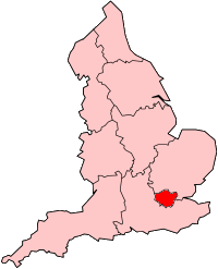
| Locale | Greater London |
| Termini |
Lewisham Hayes |
| Stations | 10 |
| Operation | |
| Opened | 1857 |
| Owner | Network Rail |
| Operator(s) | Southeastern |
| Rolling stock |
Class 376 "Electrostar" Class 465 "Networker" Class 466 "Networker" |
| Technical | |
| Number of tracks | 2 |
| Track gauge | 1,435 mm (4 ft 8 1⁄2 in) standard gauge |
| Electrification | 750 V Direct Current third rail |
| Operating speed | 60 mph (97 km/h) maximum |
Mid-Kent line (Hayes Line) | ||||||||||||||||||||||||||||||||||||||||||||||||||||||||||||||||||||||||||||||||||||||||||||||||||||||||||||||||||||||||||||||||||||||||||||||||||||||||||||||||||||||||||||||||||||||||||||||||||||||||||||||||||||||||||||||||||||||||||||||||||||||||||||||||||||||||||||||||||||||||||||||||||||||||||||||||||||||||||||||||||||||||||||||||||||
|---|---|---|---|---|---|---|---|---|---|---|---|---|---|---|---|---|---|---|---|---|---|---|---|---|---|---|---|---|---|---|---|---|---|---|---|---|---|---|---|---|---|---|---|---|---|---|---|---|---|---|---|---|---|---|---|---|---|---|---|---|---|---|---|---|---|---|---|---|---|---|---|---|---|---|---|---|---|---|---|---|---|---|---|---|---|---|---|---|---|---|---|---|---|---|---|---|---|---|---|---|---|---|---|---|---|---|---|---|---|---|---|---|---|---|---|---|---|---|---|---|---|---|---|---|---|---|---|---|---|---|---|---|---|---|---|---|---|---|---|---|---|---|---|---|---|---|---|---|---|---|---|---|---|---|---|---|---|---|---|---|---|---|---|---|---|---|---|---|---|---|---|---|---|---|---|---|---|---|---|---|---|---|---|---|---|---|---|---|---|---|---|---|---|---|---|---|---|---|---|---|---|---|---|---|---|---|---|---|---|---|---|---|---|---|---|---|---|---|---|---|---|---|---|---|---|---|---|---|---|---|---|---|---|---|---|---|---|---|---|---|---|---|---|---|---|---|---|---|---|---|---|---|---|---|---|---|---|---|---|---|---|---|---|---|---|---|---|---|---|---|---|---|---|---|---|---|---|---|---|---|---|---|---|---|---|---|---|---|---|---|---|---|---|---|---|---|---|---|---|---|---|---|---|---|---|---|---|---|---|---|---|---|---|---|---|---|---|---|---|---|---|---|---|---|---|---|---|---|---|---|---|---|---|---|---|---|---|---|---|---|
| ||||||||||||||||||||||||||||||||||||||||||||||||||||||||||||||||||||||||||||||||||||||||||||||||||||||||||||||||||||||||||||||||||||||||||||||||||||||||||||||||||||||||||||||||||||||||||||||||||||||||||||||||||||||||||||||||||||||||||||||||||||||||||||||||||||||||||||||||||||||||||||||||||||||||||||||||||||||||||||||||||||||||||||||||||||
The Mid-Kent line[1] (also referred to as the Hayes line by train operators,[2] official bodies[3] and the general public[4]) is a British railway line running from Courthill Loop North junction[5] (just south of Lewisham station) to Hayes railway station in the London Borough of Bromley. Despite its name, none of the line is in the present-day county of Kent.
Description
- Services commence at either Charing Cross via Waterloo East, or Cannon Street.
- London Bridge – North Kent Junction, Bermondsey: The pioneer London and Greenwich Railway opened its line on 8 February 1836. This section is built on a brick viaduct
- North Kent Junction – Lewisham: opened 30 July 1849 as the North Kent Railway, now called the North Kent line. Most of the railway here is in cutting with the four tracks passing through St Johns railway station, the two northernmost leading into Lewisham station.
- Lewisham – New Beckenham: opened 1 January 1857 as the Mid-Kent line. This opening created a junction at Lewisham.
- New Beckenham – Elmers End: opened on 1 April 1864 as part of an extension of the Mid-Kent line to Addiscombe
- Elmers End – Hayes: this section was built by the West Wickham & Hayes Railway, but was sold to the South Eastern Railway on opening day, 29 May 1882
Services
All services along the line are operated by Southeastern. The standard off-peak service is two trains per hour (tph) each way between London Charing Cross and Hayes, non-stop between London Bridge and Ladywell, and two tph between London Cannon Street and Hayes, calling at all stations via Lewisham. In addition, there is one train per day from Charing Cross to Beckenham Junction.
History
Early years 1857–1922
The existing Mid-Kent line consists of three sections built at different times. The Mid Kent Railway was built by the Mid-Kent and North Kent Junction Railway (MK&NKJR) and was opened on 1 January 1857 from Lewisham (where the existing station was closed and a new station re-opened at the junction) as far as Beckenham Junction (although it was not technically a junction as the West End of London and Crystal Palace Railway’s line did not open until 3 May 1858). From opening the line was worked by the South Eastern Railway (SER) and served new stations at Ladywell, Catford Bridge, Lower Sydenham and Beckenham (Junction).[6]
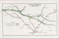
Seven years later the MK&NKJR built an extension from a new junction station at New Beckenham to Croydon (Addiscombe Road) which again was operated by the SER.[7] The line diverged from the 1857 line to the west of Beckenham Junction and a new station was built in the junction area. This was re-located northwards two years later.
In September 1866 a short spur was opened from the north end of Ladywell station to the recently opened South Eastern Main Line avoiding Lewisham station, which it joins at Parks Bridge Junction.[8]
The Elmers End – Hayes section was built by the West Wickham & Hayes Railway, but was sold to the South Eastern Railway in 1881, opening on 29 May 1882. Intermediate stations were opened at Eden Park and West Wickham.
Clock House station was opened in June 1890.
In 1898 the South Eastern Railway and its bitter rivals the London Chatham and Dover Railway agreed to work as one railway company under the name of the South Eastern and Chatham Railway and thus the stations became an SECR stations.
The original Lower Sydenham station was closed and moved half a mile south in 1906 in an attempt to develop a new area for housing.
On 14 June 1913 members of the Suffragettes movement planted a bomb which was discovered in the ladies waiting room at Eden Park railway station. The clockwork mechanism had stopped working and so it didn’t go off. This event followed the death of Emily Wilding Davison six days earlier after her attempt to stop the King’s horse at The Derby.[9]
Southern Railway 1923–1947
Following the Railways Act 1921 (also known as the Grouping Act), the Mid-Kent line came under the control of the Southern Railway. The line was electrified with other SECR suburban routes in 1926.
Hayes, West Wickham and Elmers End stations were all damaged by enemy bombs during the Second World War.
British Railways 1948–1994
After World War II and following nationalisation on 1 January 1948, the line became part of British Railways Southern Region.
In 1956 platform lengths were extended to accommodate 10-car trains.
During the 1960s the local goods yards at Catford Bridge, Lower Sydenham, Clock House, Elmers End, West Wickham and Hayes all closed as did the gas works internal railway at Lower Sydenham.
Colour light signalling was introduced south of Ladywell (as far as New Beckenham) on 4 April 1971.[10] The line was fully converted to colour light operation in September 1975 under the control of London Bridge Signalling Centre. The old mechanical signal boxes closed at this time.[11]
Upon sectorisation in 1982, the line came under the control of the London & South East sector, which was renamed Network SouthEast in 1986.[12]
Goods services were withdrawn in 1964 with the exception of Beckenham Junction which survived until 1982.[13]
During the planning of the London Underground Fleet line, now the Jubilee line, it was suggested that the Mid-Kent line be taken over. However a more northerly alignment was instead taken. The section from Elmers End to Addiscombe was closed in 1997 and taken over by Tramlink operations.
Future plans
It has been proposed that the Bakerloo line will be extended from its current terminus at Elephant & Castle to Hayes via Camberwell and Lewisham or Honor Oak.[14][15] More so, recently Network Rail's Kent Route Utilisation Strategy, published in 2010 envisages the ultimate incorporation of the Hayes Line into an extended Bakerloo line . Furthermore, if this were to happen, services on the Hayes line would be replaced by London Underground services and a most-likely withdrawal of National Rail services. Also, the Beckenham Junction branch will also be incorporated into the new extended line potentially meaning an all-day service. The driving force for this change is that Network Rail would like the train paths freed up for services mainly from the South Eastern Main Line . Transport for London prefer this route due to its being largely self-contained after Lewisham . An alternative plan has also been put forward by the Brighton Main Line 2 pressure group to use the line as part of an alternative route from Sussex to London. This would involve re-opening the old link from Sanderstead to Elmers End and avoid the railway bottleneck at East Croydon.
References
- ↑ Quail Map 5 – England South [page 4]. September 2002. Retrieved 2011-12-05.
- ↑ "Lines of route". Southeastern. Archived from the original on 2012-09-28.
- ↑ "TfL funds Hayes Line station improvements" (Press release). Transport for London. 17 September 2004.
- ↑ http://www.londonbanter.co.uk/london-transport/1368-hayes-kent-line.html
- ↑ Network Rail (April 2001). South Zone Sectional Appendix. Module SO. p. SO330 1/118. SO/SA/001A.
- ↑ "The History of Railways in Beckenham". Beckenham History. Retrieved 22 February 2011.
- ↑ Jackson, Alan A (1999). London's Local Railways (2nd ed.). Harrow Weald: Capital Transport Publishing. pp. 37–40.
- ↑ Jackson, Alan A (1999). London's Local Railways (2nd ed.). Harrow Weald: Capital Transport Publishing. p. 37.
- ↑ Gray, Lesley. "Suffragette timeline". The King's Jockey. Lesley Gray. Retrieved 29 May 2016.
- ↑ Jackson, Alan A (1999). London's Local Railways (2nd ed.). Harrow Weald: Capital Transport Publishing. p. 47.
- ↑ Mitchell, Vic; Smith, Keith (September 1993). London Bridge to Addiscombe. Midhurst, UK: Middleton Press. p. 83. ISBN 1 873793 20 0.
- ↑ Thomas, David St John; Whitehouse, Patrick (1990). BR in the Eighties. Newton Abbot: David & Charles. ISBN 0-7153-9854-7.
- ↑ "The Railways of Beckenham", Andrew Hajducki, 2011
- ↑ John Bull (24 August 2009). "Extending the Bakerloo: Investigations and Options". London Reconnections. Archived from the original on 23 August 2012. Retrieved 18 March 2014.
- ↑ Lewisham Council (n.d.). "Catford plan – frequently asked questions". Retrieved 18 March 2014.