Michigan's congressional districts
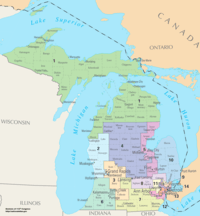
Michigan is divided into 14 congressional districts, each represented by a member of the United States House of Representatives.[2]
The districts are currently represented in the 115th United States Congress by 4 Democrats, 9 Republicans, and 1 seat is vacant.
Current districts and representatives
List of members of the Michigan United States House delegation, their time in office, district maps, and the districts' political ratings according to the CPVI. The delegation has a total of 14 members, although one of those seats is vacant. Of the remaining members, there are 9 Republicans and 4 Democrats.
"Time in office" reflects each member's time since becoming a U.S. Representative, not the member's time since becoming a representative for his current district; redistricting commonly results in a district being moved elsewhere in the state and its representative beginning to represent a different district in the same location.
| District | Representative | Party | CPVI | Time in office | District map |
|---|---|---|---|---|---|
| 1st |  |
Republican | R+9 | January 3, 2017 – present | .tif.png) |
| 2nd |  |
Republican | R+9 | January 3, 2011 – present | .tif.png) |
| 3rd |  |
Republican | R+6 | January 3, 2011 – present | .tif.png) |
| 4th |  |
Republican | R+10 | January 3, 2015 – present | .tif.png) |
| 5th |  |
Democratic | D+5 | January 3, 2013 – present | .tif.png) |
| 6th |  |
Republican | R+4 | January 3, 1987 – present | .tif.png) |
| 7th |  |
Republican | R+7 | January 3, 2011 – present | .tif.png) |
| 8th |  |
Republican | R+4 | January 3, 2015 – present | .tif.png) |
| 9th |  |
Democratic | D+4 | January 3, 1983 – present | .tif.png) |
| 10th |  |
Republican | R+13 | January 3, 2017 – present | .tif.png) |
| 11th |  |
Republican | R+4 | January 3, 2015 – present | .tif.png) |
| 12th |  |
Democratic | D+14 | January 3, 2015 – present | .tif.png) |
| 13th | Vacant | D+31 | Vacant since December 5, 2017 | .tif.png) | |
| 14th | .jpg) |
Democratic | D+30 | January 3, 2015 – present | .tif.png) |
Historical district boundaries
Below is a table of United States congressional district boundary maps for the State of Michigan, presented chronologically forward.[3] All redistricting events that took place in Michigan in the decades between 1973 and 2013 are shown.
| Year | Statewide map | Congressional Delegation |
|---|---|---|
| 1973–1982 |  |
1/3/1973–1/3/1974: 7 Democrats, 12 Republicans
1/3/1974–1/3/1975: 9 Democrats, 10 Republicans 1/3/1975–1/3/1977: 12 Democrats, 7 Republicans 1/3/1977–1/3/1979: 11 Democrats, 8 Republicans 1/3/1979–1/3/1981: 13 Democrats, 6 Republicans 1/3/1981–1/3/1983: 12 Democrats, 7 Republicans |
| 1983–1992 | 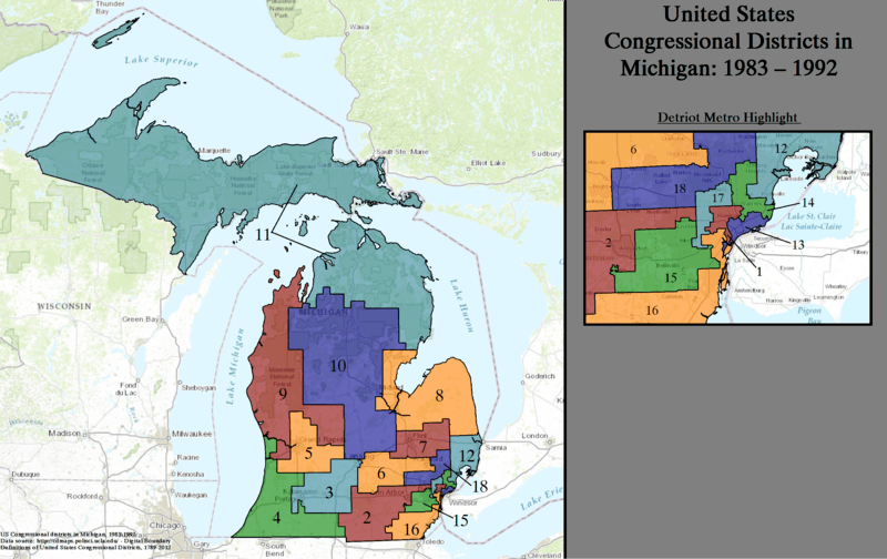 |
1/3/1983–1/3/1985: 12 Democrats, 6 Republicans
1/3/1985–1/3/1987: 11 Democrats, 7 Republicans 1/3/1987–1/3/1989: 11 Democrats, 7 Republicans 1/3/1989–1/3/1991: 11 Democrats, 7 Republicans 1/3/1991–1/3/1993: 11 Democrats, 7 Republicans |
| 1993–2002 | 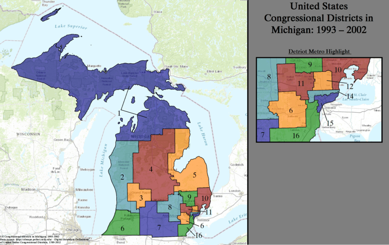 Note: The orange 6th is mislabeled; it should read 13th. |
1/3/1993–1/3/1995: 10 Democrats, 6 Republicans 1/3/1995–1/3/1997: 9 Democrats, 7 Republicans 1/3/1997–1/3/1999: 10 Democrats, 6 Republicans 1/3/1999-1/3/2001: 10 Democrats, 6 Republicans 1/3/2001-1/3/2003: 9 Democrats, 7 Republicans |
| 2003–2013 |  |
1/3/2003-1/3/2005: 6 Democrats, 9 Republicans
1/3/2005-1/3/2007: 6 Democrats, 9 Republicans 1/3/2007-1/3/2009: 6 Democrats, 9 Republicans 1/3/2009-1/3/11: 8 Democrats, 7 Republicans 1/3/2011–7/6/2012: 6 Democrats, 9 Republicans 7/6/2012-11/6/2012: 6 Democrats, 8 Republicans, 1 Vacant seat 11/6/2012-1/3/2013: 7 Democrats, 8 Republicans |
| Since 2013 | 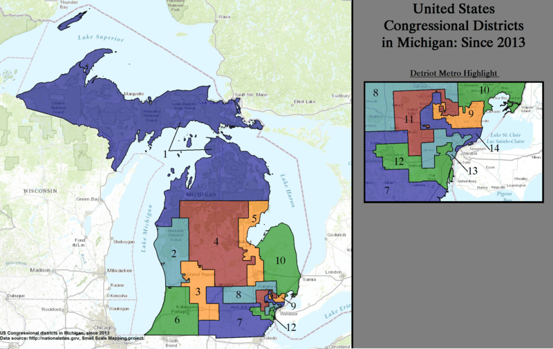 |
1/3/2013–1/3/2015: 5 Democrats, 9 Republicans
1/3/2015–1/3/2017: 5 Democrats, 9 Republicans 1/3/2017-12/5/2017: 5 Democrats, 9 Republicans 12/5/2017-present: 4 Democrats, 9 Republicans, 1 Vacant seat |
Obsolete districts
See also
References
- ↑ "The national atlas". nationalatlas.gov. Archived from the original on February 22, 2014. Retrieved February 22, 2014.
- ↑ "Directory of Representatives". The United States House of Representatives. Retrieved 2013-03-08.
- ↑ "Digital Boundary Definitions of United States Congressional Districts, 1789–2012". Retrieved October 18, 2014.