Mica Peak (Washington)
| Mica Peak | |
|---|---|
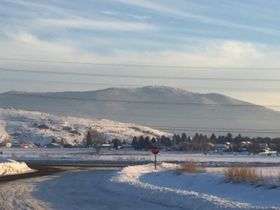 Mica Peak Viewed from Broadway Avenue in Liberty Lake. | |
| Highest point | |
| Elevation | 5,209 ft (1,588 m) [1] |
| Prominence | 1,525 ft (465 m) [1] |
| Coordinates | 47°34′24″N 117°04′52″W / 47.5732330°N 117.0810287°WCoordinates: 47°34′24″N 117°04′52″W / 47.5732330°N 117.0810287°W [1] |
| Geography | |
| Location | Spokane County, Washington |
| Parent range | Selkirk Mountains |
| Topo map | USGS Rockford Bay |
Mica Peak is a mountain summit in Spokane County in the U.S. state of Washington. Mica Peak climbs to 5,209 feet (1,588 m) above sea level. The mountain is the southernmost peak in the Selkirk range, and separates the Palouse, from the Spokane Valley.[2] The nearby Mica Peak in Idaho, which is 31 feet taller, was originally called Signal Peak. Due to the fact that the two mountains are almost continuous with each other, people began mistakenly calling Signal Peak, Mica Peak. The name stuck, leaving two mountains with the same name only 5.49 miles apart.
See Also
References
- 1 2 3 "Mica Peak, Washington". Peakbagger.com. Retrieved 2016-09-02.
- ↑ "SummitPost". SummitPost.org. Retrieved 2016-09-01.
This article is issued from
Wikipedia.
The text is licensed under Creative Commons - Attribution - Sharealike.
Additional terms may apply for the media files.