Mian Kalay Shangla
| Mian Kalay (میاں کلے ) Mian Kalay | |
|---|---|
| Village/Town | |
 | |
 Mian Kalay (میاں کلے ) | |
| Coordinates: 34°54′N 72°41′E / 34.900°N 72.683°ECoordinates: 34°54′N 72°41′E / 34.900°N 72.683°E | |
| Country |
|
| Province | Khyber-Pakhtunkhwa |
| District | Shangla District |
| Tehsil | Tehsil Alpurai |
| Union Council | Pirabad Union Council |
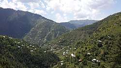
Mian Kalay (میاں کلے) is a town of Tehsil Alpurai in Shangla District of Khyber-Pakhtunkhwa province of Pakistan. It is the main village of Pirabd Union Council of Tehsil Alpurai and a commercial place for the business community. Mian Kalay is a town of the Pirabad Union Council (U.C) of Tehsil Alpurai, located at 34°54'15N 72°41'45E and lies in the area affected by the 2005 earthquake and 2010 Flood.[1]
References
- ↑ Population Census Organisation (Pakistan). (1999). 1998 district census report of [name of district]. Population Census Organisation, Statistics Division, Govt. of Pakistan.
This article is issued from
Wikipedia.
The text is licensed under Creative Commons - Attribution - Sharealike.
Additional terms may apply for the media files.