Merrylands West, New South Wales
| Merrylands West Sydney, New South Wales | |||||||||||||||
|---|---|---|---|---|---|---|---|---|---|---|---|---|---|---|---|
 Central Gardens | |||||||||||||||
|
Merrylands West | |||||||||||||||
| Coordinates | 33°50′15″S 150°57′42″E / 33.83750°S 150.96167°ECoordinates: 33°50′15″S 150°57′42″E / 33.83750°S 150.96167°E | ||||||||||||||
| Population | 6,592 (2016 census)[1] | ||||||||||||||
| Postcode(s) | 2160 | ||||||||||||||
| Location | 27 km (17 mi) west of Sydney CBD | ||||||||||||||
| LGA(s) | Cumberland Council | ||||||||||||||
| State electorate(s) | Granville | ||||||||||||||
| Federal Division(s) | |||||||||||||||
| |||||||||||||||
Merrylands West is a suburb in western Sydney, New South Wales, Australia. Merrylands West is located 27 kilometres west of the Sydney central business district in the local government area of the Cumberland Council. The eastern part of Merrylands West is known locally as Hilltop
Commercial area
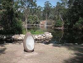
Merrylands West contains several schools - Merrylands High School, Cerdon College- an all-girls school, and Sherwood Grange Public School. There is a retirement village situated on Kenyons Road, behind the high schools. The suburb is commercially serviced by a small shopping centre comprising a supermarket and fast food outlets. Merrylands West also contains the Central Gardens - a small wildlife park in Sydney's west. An elementary school, Hilltop Road Public School, is located in the suburb.
Transport
There are two T-way stops in Merrylands West - the Sherwood stop near the main intersection, and the Canal stop in front of the two high schools. The area is also serviced by other local bus companies.
References
- ↑ Australian Bureau of Statistics (27 June 2017). "Merrylands West (State Suburb)". 2016 Census QuickStats. Retrieved 14 March 2018.
