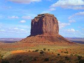
Merrick Butte
| Merrick Butte | |
|---|---|
 | |
| Highest point | |
| Elevation | 6,206 ft (1,892 m) NAVD 88[1] |
| Prominence | 966 ft (294 m) [1] |
| Coordinates | 36°58′50″N 110°05′09″W / 36.9805572°N 110.0859588°WCoordinates: 36°58′50″N 110°05′09″W / 36.9805572°N 110.0859588°W [2] |
| Geography | |
 Merrick Butte | |
| Location | Navajo County, Arizona. U.S. |
| Topo map | USGS Mitten Buttes |
Merrick Butte is a butte located in Monument Valley in the extreme northeast of Navajo County, Arizona. It is located 1.4 miles (2.3 km) east of the monument headquarters and 1.25 miles (2.01 km) south of the Arizona–Utah state line,[3] and is part of the Monument Valley Navajo Tribal Park, similar to its neighbors' West and East Mitten Buttes just to the north.[4]
References
- 1 2 "Merrick Butte". Peakbagger.com. Retrieved 2016-08-22.
- ↑ "Merrick Butte". Geographic Names Information System. United States Geological Survey. Retrieved 2016-08-22.
- ↑ Mitten Buttes Quadrangle, Arizona-Utah, 7.5 Minute Series, US Geological Survey, 1738 ed.
- ↑ Arizona Atlas & Gazetteer, De Lorme, 4th ed., 2001, p. 26 ISBN 0-89933-325-7
External links

This article is issued from
Wikipedia.
The text is licensed under Creative Commons - Attribution - Sharealike.
Additional terms may apply for the media files.