Melrose, Louisiana
| Melrose | |
| Unincorporated community | |
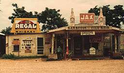 Frenchie's Bar, Melrose, 1944. Photo by Marion Post Wolcott. | |
| Country | United States |
|---|---|
| State | Louisiana |
| Parish | Natchitoches |
| Elevation | 108 ft (32.9 m) |
| Coordinates | 31°35′56″N 92°58′02″W / 31.59889°N 92.96722°WCoordinates: 31°35′56″N 92°58′02″W / 31.59889°N 92.96722°W |
| Timezone | CST (UTC-6) |
| - summer (DST) | CDT (UTC-5) |
| Area code | 318 |
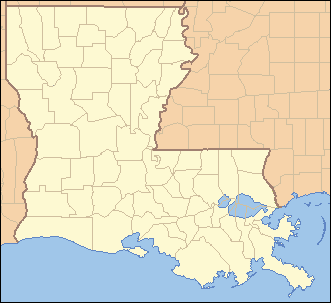 Location of Melrose in Louisiana | |
 Location of Louisiana in the United States | |
Melrose is an unincorporated community in Natchitoches Parish, Louisiana, United States, including the Melrose Plantation and surrounding area, on Louisiana Highway 119. In addition to the historic plantation, the Cane River Creole National Historical Park and Heritage Area encompass the Melrose area.
Melrose is part of the Natchitoches Micropolitan Statistical Area.
External links
Municipalities and communities of Natchitoches Parish, Louisiana, United States | ||
|---|---|---|
| City | 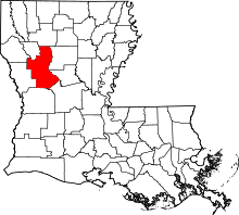 | |
| Town | ||
| Villages | ||
| CDPs | ||
| Other unincorporated communities |
| |
| Footnotes | ‡This populated place also has portions in an adjacent county or counties | |
This article is issued from
Wikipedia.
The text is licensed under Creative Commons - Attribution - Sharealike.
Additional terms may apply for the media files.