Melissia
| Melissia Μελίσσια | |
|---|---|
 The Beehives' Land | |
 Melissia Location within Athens 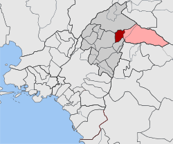 | |
| Coordinates: 38°3′N 23°50′E / 38.050°N 23.833°ECoordinates: 38°3′N 23°50′E / 38.050°N 23.833°E | |
| Country | Greece |
| Administrative region | Attica |
| Regional unit | North Athens |
| Municipality | Penteli |
| • Municipal unit | 3.956 km2 (1.527 sq mi) |
| Elevation | 290 m (950 ft) |
| Population (2011)[1] | |
| • Municipal unit | 22,741 |
| • Municipal unit density | 5,700/km2 (15,000/sq mi) |
| Time zone | UTC+2 (EET) |
| • Summer (DST) | UTC+3 (EEST) |
| Postal code | 151 xx |
| Area code(s) | 210 |
| Vehicle registration | Z |
| Website | www.melissia.gr |
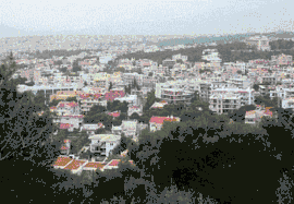
Melissia (Greek: Μελίσσια) is a suburb in the northeastern part of the Athens agglomeration, Greece. Since the 2011 local government reform it is part of the municipality Penteli, of which it is the seat and a municipal unit.[2] The municipal unit has an area of 3.956 km2.[3] Melissia is situated at the southwestern foot of the Penteli mountains, 12 km northeast of Athens city centre. It is a green residential town.
It was part of the municipality of Marousi until 1946, when it became a separate community. It became a municipality in 1990.[4] The population of Melissia was more than 22,000 at the 2011 census. It has six primary schools, two high schools (Greek "Gymnasium"), one lyceum and a modern municipal swimming-pool.
Historical population

Melissia Main Square
| Year | Population |
|---|---|
| 1981 | 8,639 |
| 1991 | 13,469 |
| 2001 | 19,526 |
| 2011 | 22,741 |
See also
References
- ↑ "Απογραφή Πληθυσμού - Κατοικιών 2011. ΜΟΝΙΜΟΣ Πληθυσμός" (in Greek). Hellenic Statistical Authority.
- ↑ Kallikratis law Greece Ministry of Interior (in Greek)
- ↑ "Population & housing census 2001 (incl. area and average elevation)" (PDF) (in Greek). National Statistical Service of Greece. Archived from the original (PDF) on 2015-09-21.
- ↑ EETAA local government changes
External links
- Official website (in Greek)
Places adjacent to Melissia | ||||||||||
|---|---|---|---|---|---|---|---|---|---|---|
| ||||||||||
This article is issued from
Wikipedia.
The text is licensed under Creative Commons - Attribution - Sharealike.
Additional terms may apply for the media files.