Division of Melbourne Ports
| Melbourne Ports Australian House of Representatives Division | |
|---|---|
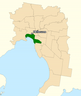 Division of Melbourne Ports in Victoria, as of the 2016 federal election. | |
| Created | 1901 |
| MP | Michael Danby |
| Party | Labor |
| Namesake | Port Melbourne |
| Electors | 102,283 (2016) |
| Area | 40 km2 (15.4 sq mi) |
| Demographic | Inner Metropolitan |
The Division of Melbourne Ports is an Australian federal electoral division in the inner south-eastern suburbs of Melbourne, Victoria, Australia. It is located to the south of Melbourne's central business district and covers an area of approximately 40 km2 around the north and north-eastern shores of Port Phillip Bay.
The electorate was created at the time of Australian Federation in 1901 and was one of the original 65 divisions contested at the first federal election. It is named for the fact that at the time of its creation it was centred on Port Melbourne and Williamstown, both major ports.
The electorate, formerly working class, is much more demographically diverse on its current boundaries, with rapidly accelerating inner-city gentrification and high-density housing developments in recent years. It still includes Port Melbourne, but now also includes a number of middle and upper middle class suburbs such as Albert Park, Balaclava, Caulfield, Elwood, Middle Park, Ripponlea, South Melbourne and St Kilda. It is notable for having one of Australia's larger Jewish populations, at 9.9%, much higher than the nationwide 0.4%. It also has a high proportion of atheists and agnostics, with 38.8% of residents answering "No Religion" in the 2016 census, compared to 30.1% nationwide.[1] It also has a large gay and lesbian community.
Melbourne Ports has been held by the Australian Labor Party since 1906. It has been held by only five men since 1906, most notably Jack Holloway, a minister in the Curtin government, Frank Crean, Treasurer and then Deputy Prime Minister in the Whitlam government, and Clyde Holding, a minister in the Hawke government and before then state Labor leader in Victoria.
Originally, it was anchored in the industrial suburbs in the west of the electorate, which are part of Labor's heartland in west Melbourne. On those boundaries, for decades it was one of the safest Labor seats in the country, and Labor usually easily retained it even during severe nationwide defeats for Labor. Since its extension eastwards to Caulfield and other Liberal-voting areas in the 1990 redistribution, it has become much less secure for Labor. Continuing the gradual downwards trend in the Labor primary vote, in the 2013 election, Labor was returned with a primary vote of less than 32 percent. In 2016, Labor actually suffered a primary vote swing of four percent and a two-party swing of two percent even as it nearly reduced the Coalition to minority government nationally.
In 2018, the Australian Electoral Commission proposed renaming Melbourne Ports to Macnamara, after medical scientist Dame Jean Macnamara.[2] The new name was gazetted on 13 July 2018, and will be used from the next Federal election.[3]
Members
| Member | Party | Term | |
|---|---|---|---|
| Samuel Mauger | Protectionist | 1901–1906 | |
| James Mathews | Labor | 1906–1931 | |
| Jack Holloway | Labor | 1931–1951 | |
| Frank Crean | Labor | 1951–1977 | |
| Clyde Holding | Labor | 1977–1998 | |
| Michael Danby | Labor | 1998–present | |
Election results
| Party | Candidate | Votes | % | ± | |
|---|---|---|---|---|---|
| Liberal | Owen Guest | 35,533 | 41.90 | +0.85 | |
| Labor | Michael Danby | 22,897 | 27.00 | −4.67 | |
| Greens | Steph Hodgins-May | 20,179 | 23.79 | +3.62 | |
| Animal Justice | Robert Smyth | 1,685 | 1.99 | +1.99 | |
| Independent | Peter Holland | 1,393 | 1.64 | +1.64 | |
| Marriage Equality | Henry von Doussa | 1,349 | 1.59 | +1.59 | |
| Drug Law Reform | Levi McKenzie-Kirkbright | 1,348 | 1.59 | +1.59 | |
| Independent | John Myers | 425 | 0.50 | +0.50 | |
| Total formal votes | 84,809 | 95.76 | −0.42 | ||
| Informal votes | 3,756 | 4.24 | +0.42 | ||
| Turnout | 88,565 | 86.59 | −3.45 | ||
| Two-party-preferred result | |||||
| Labor | Michael Danby | 43,573 | 51.38 | −2.18 | |
| Liberal | Owen Guest | 41,236 | 48.62 | +2.18 | |
| Labor hold | Swing | −2.18 | |||