Meløya
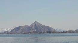 View of the island | |
 Meløya Location in Nordland | |
| Geography | |
|---|---|
| Location | Nordland, Norway |
| Coordinates | 66°49′58″N 13°27′23″E / 66.8327°N 13.4563°ECoordinates: 66°49′58″N 13°27′23″E / 66.8327°N 13.4563°E |
| Area | 21.8 km2 (8.4 sq mi) |
| Length | 11 km (6.8 mi) |
| Width | 3 km (1.9 mi) |
| Highest elevation | 582 m (1,909 ft) |
| Highest point | Meløytinden |
| Administration | |
| County | Nordland |
| Municipality | Meløy |
| Demographics | |
| Population | 201 (2001) |
Meløya is an island in the municipality of Meløy in Nordland county, Norway. The island lies east of Bolga, north of Åmnøya, and west of Mesøya. The 21.8-square-kilometre (8.4 sq mi) island is only accessible by boat, and there are regular ferry connections to Bolga, Støtt, Vassdalsvik, and Ørnes.
The western part of the island is relatively flat and has many farms. The village of Meløy is located in this area and it is the main population centre on the island. Meløy Church is located in the village of Meløy. The village of Meløy was the administrative centre of Meløy until 1952 when it was moved to Ørnes. The eastern part of the island is mountainous, and it is dominated by the 582-metre (1,909 ft) tall Meløytinden.[1]
See also
References
- ↑ Store norske leksikon. "Meløya" (in Norwegian). Retrieved 2012-02-06.
This article is issued from
Wikipedia.
The text is licensed under Creative Commons - Attribution - Sharealike.
Additional terms may apply for the media files.