Medeon (Phocis)
Coordinates: 38°22′03″N 22°40′58″E / 38.36754°N 22.6827°E

Medeon (Ancient Greek: Μεδεών)[1] was a town of ancient Phocis, destroyed by Philip II of Macedon along with the other Phocian towns at the termination of the Third Sacred War (in 346 BCE), and never again restored.[2] Strabo places it on the Crissaean Gulf, at the distance of 160 stadia from Boeotia;[3] and Pausanias says that it was near Anticyra.[4]
An inscription is preserved dating from the 2nd century BCE regarding a political and religious union (sympoliteia) between Medeon and Stiris, in which both cities had the approval of the Phocian League. The agreement was inscribed on a stele inside the temple of Athena Cranea, in the city of Elateia. The stele preserves the name of the League's strategus, Zeuxis; in addition a sealed copy was to be guarded by a citizen of Lilaea named Trason and there were three persons who acted as witnesses from different Phocian cities: Tithorea, Elateia, and Lilaea. The union included the sanctuaries, the territory, the polis and the ports.
From the formalization of the treaty the Medeonites will be with the Stirisians in conditions of equality and will have assemblies and common magistrates. It is not a complete merger of both cities: Stiris is the main city but the citizens of Medeon could designate a hierotamia who would make sacrifices according to the law of Medeon and who would have judicial competency together with the archons of Stiris and could vote. Those who have been magistrates in Medeon will not be required to be so in Stiris unless they decided voluntarily. The administration of the Medeonite sanctuaries will be carried out according to the law of Medeon, and the territory will be common.[5]

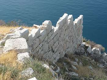
Medon's location is at a hill site called Agii Theodoroi.[6][7] The first excavations on the hill were carried out by Georgios Sotiriadis in 1907. Subsequently the site was re-excavated during the 1960s. An ancient cemetery has been found that remained in use from the Middle Heladic period (2100-1600 BCE) until the 2nd century BCE. A beehive tomb (tholos) with a small side room has also been discovered. Additionally, the fortification walls, which were built in the 4th century BCE, remain.[8]
References
- ↑ Stephanus of Byzantium. Ethnica. s.v.
- ↑ Pausanias. Description of Greece. 10.3.2.
- ↑ Strabo. Geographica. ix. pp. 410, 423. Page numbers refer to those of Isaac Casaubon's edition.
- ↑ Pausanias. Description of Greece. 10.36.6.
- ↑ José Pascual (2007). "La sympoliteia griega en las épocas clásica y helenística". Gerión (in Spanish) (167 ed.). Madrid: Universidad Autónoma de Madrid. 25 (1): 177, 181, 182.
- ↑ Lund University. Digital Atlas of the Roman Empire.
- ↑ Richard Talbert, ed. (2000). Barrington Atlas of the Greek and Roman World. Princeton University Press. p. 55, and directory notes accompanying.
- ↑ Ministry of Culture of Greece: the acropolis of ancient Medeon (in Greek)
![]()