Mebaireek
| Mebaireek | |
|---|---|
| Settlement | |
 Mebaireek | |
| Coordinates: 25°11′24″N 51°22′48″E / 25.1900°N 51.3800°ECoordinates: 25°11′24″N 51°22′48″E / 25.1900°N 51.3800°E | |
| Country | Qatar |
| Municipality | Al Rayyan |
| Area | |
| • Total | 160.5 km2 (62.0 sq mi) |
| Population (2015)[1] | |
| • Total | 12,483 |
| • Density | 78/km2 (200/sq mi) |
Mebaireek is a settlement in Qatar, located in the municipality of Al Rayyan.[2] It was formalized as one of Al Rayyan's ten administrative zones in the mid-2000s as a result of a merger between the two administrative zones of Abu Nakhla and Al Mukaynis. At present, these two areas are considered localities of Mebaireek.[3]
Localities
Abu Nakhla
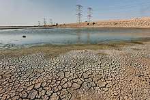
The Abu Nakhla locality of Mebaireek is one of five sites for the government-sponsored project to develop reservoirs in the country.[4] Once completed, the reservoirs are expected to be the largest in the world in their category,[5] with a total length of 650 km and constructed at a cost of QR 14.5 billion. In June 2018, the first phase of the project was completed.[6]
Al Mukaynis
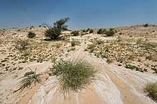
Two notable landmarks in Al Mukaynis are Mudhlem Cave[7] and Arakhiya Farm.[8]
Demographics
As of the 2010 census, the settlement comprised 1,002 housing units[9] and 145 establishments.[10] There were 11,333 people living in the settlement, of which 50% were male and 50% were female. Out of the 11,333 inhabitants, 62% were 20 years of age or older and 38% were under the age of 20.[11]
Employed persons made up 40% of the total population. Females accounted for 46% of the working population, while males accounted for 54% of the working population.[11]
| Year | Population |
|---|---|
| 1986[12] | 427 |
| 1997[13] | 1,469 |
| 2004[3] | 6,287 |
| 2010[2] | 11,333 |
| 2015[1] | 12,483 |
Education
The follows school is located in Mebaireek:
| Name of School | Curriculum | Grade | Genders | Official Website | Ref |
|---|---|---|---|---|---|
| Abdullah bin Jassim Al Thani Boys School | Independent | Kindergarten – Primary | Male-only | N/A | [14] |
Gallery
Click on the thumbnail to enlarge.
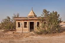 Dilapidated mosque near the water reservoirs in Abu Nakhla.
References
- 1 2 "2015 Population census" (PDF). Ministry of Development Planning and Statistics. April 2015. Retrieved 8 August 2017.
- 1 2 "2010 population census" (PDF). Qatar Statistics Authority. Archived from the original (PDF) on 2 April 2015. Retrieved 29 June 2015.
- 1 2 "2004 population census". Qatar Statistics Authority. Retrieved 1 July 2015.
- ↑ "رئيس الوزراء: يطلق مشروع الخزانات الاستراتيجية الكبرى لتأمين المياه". Qatar Government. 13 May 2015. Retrieved 17 December 2015.
- ↑ Amery, Hussain A. (15 June 2015). Arab Water Security: Threats and Opportunities in the Gulf States. Cambridge University Press. p. 121. ISBN 9781316381069.
- ↑ Sanaullah Ataullah (29 June 2018). "PM opens first phase of QR14.5bn reservoirs project". The Peninsula. Retrieved 29 June 2018.
- ↑ Heidelberger, Mark. "What Caves Are In Qatar". USA Today. Retrieved 9 July 2015.
- ↑ "Newsletter". 1 (2). Qatar Bird Club. April 2010.
- ↑ "Housing units, by type of unit and zone (April 2010)" (PDF). Qatar Statistics Authority. Archived from the original (PDF) on 8 July 2015. Retrieved 7 August 2015.
- ↑ "Establishments by status of establishment and zone (April 2010)" (PDF). Qatar Statistics Authority. Archived from the original (PDF) on 8 July 2015. Retrieved 7 August 2015.
- 1 2 "Geo Statistics Application". Ministry of Development Planning and Statistics. Archived from the original on 11 September 2012. Retrieved 7 August 2015.
- ↑ "1986 population census" (PDF). Qatar Statistics Authority. Archived from the original (PDF) on 3 July 2015. Retrieved 2 July 2015.
- ↑ "1997 population census" (PDF). Qatar Statistics Authority. Archived from the original (PDF) on 29 May 2015. Retrieved 2 July 2015.
- ↑ "Abdullah bin Jassim Al Thani Boys Model Independent". Supreme Education Council. Retrieved 19 July 2015.
Capital: Al Rayyan City | |
| Administrative zones |
|
| Other areas |
|
| Landmarks | |