McGregor, Texas
| McGregor, Texas | |
|---|---|
| City | |
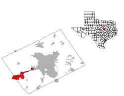
 Location of McGregor, Texas | |
 | |
| Coordinates: 31°25′55″N 97°25′1″W / 31.43194°N 97.41694°WCoordinates: 31°25′55″N 97°25′1″W / 31.43194°N 97.41694°W | |
| Country | United States |
| State | Texas |
| Counties | McLennan, Coryell |
| Area | |
| • Total | 21.4 sq mi (55.5 km2) |
| • Land | 21.4 sq mi (55.5 km2) |
| • Water | 0.0 sq mi (0.0 km2) |
| Elevation | 692 ft (211 m) |
| Population (2010) | |
| • Total | 4,987 |
| • Density | 233/sq mi (89.9/km2) |
| Time zone | UTC-6 (Central (CST)) |
| • Summer (DST) | UTC-5 (CDT) |
| ZIP code | 76657 |
| Area code(s) | 254 |
| FIPS code | 48-45672[1] |
| GNIS feature ID | 1362469[2] |
| Website |
www |
McGregor is a city in McLennan and Coryell counties in the U.S. state of Texas. The population was 4,987 at the 2010 census.[3]
McGregor lies in two counties, as well as two metropolitan areas. The McLennan County portion of the city is part of the Waco Metropolitan Statistical Area, while the small portion that lies in Coryell County is part of the Killeen–Temple–Fort Hood Metropolitan Statistical Area.
Geography
McGregor is located in western McLennan County at 31°25′55″N 97°25′1″W / 31.43194°N 97.41694°W (31.431928, -97.417022).[4] It extends westward into Coryell County, surrounding McGregor Industrial Park, a former Naval Weapons Reserve Plant.[5]
U.S. Route 84 passes through the city center, leading northeast 17 miles (27 km) to Waco and west 20 miles (32 km) to Gatesville. Texas State Highway 317 crosses US 84 near the city center, leading north 15 miles (24 km) to Valley Mills and south 28 miles (45 km) to Belton.
According to the United States Census Bureau, McGregor has a total area of 21.4 square miles (55.5 km2), all of it land.[3]
Demographics
| Historical population | |||
|---|---|---|---|
| Census | Pop. | %± | |
| 1890 | 774 | — | |
| 1900 | 1,435 | 85.4% | |
| 1910 | 1,864 | 29.9% | |
| 1920 | 2,081 | 11.6% | |
| 1930 | 2,041 | −1.9% | |
| 1940 | 2,062 | 1.0% | |
| 1950 | 2,669 | 29.4% | |
| 1960 | 4,642 | 73.9% | |
| 1970 | 4,365 | −6.0% | |
| 1980 | 4,513 | 3.4% | |
| 1990 | 4,683 | 3.8% | |
| 2000 | 4,727 | 0.9% | |
| 2010 | 4,987 | 5.5% | |
| Est. 2016 | 5,071 | [6] | 1.7% |
| U.S. Decennial Census[7] | |||
As of the census[1] of 2000, 4,727 people, 1,728 households, and 1,206 families resided in the city. The population density was 216.7 people per square mile (83.6/km²). There were 1,856 housing units at an average density of 85.1/sq mi (32.8/km²). The racial makeup of the city was 71.10% White, 11.53% African American, 1.02% Native American, 0.38% Asian, 14.41% from other races, and 1.57% from two or more races. Hispanics or Latinos of any race were 27.27% of the population.
Of the 1,728 households, 33.1% had children under the age of 18 living with them, 51.4% were married couples living together, 13.4% had a female householder with no husband present, and 30.2% were not families. About 27.7% of all households were made up of individuals, and 15.2% had someone living alone who was 65 years of age or older. The average household size was 2.63 and the average family size was 3.21.
In the city, the population was distributed as 27.7% under the age of 18, 9.1% from 18 to 24, 25.4% from 25 to 44, 18.6% from 45 to 64, and 19.3% who were 65 years of age or older. The median age was 36 years. For every 100 females, there were 85.6 males. For every 100 females age 18 and over, there were 81.1 males.
The median income for a household in the city was $33,200, and for a family was $37,143. Males had a median income of $31,250 versus $18,605 for females. The per capita income for the city was $16,311. About 10.9% of families and 14.9% of the population were below the poverty line, including 19.1% of those under age 18 and 16.3% of those age 65 or over.
Economy
McGregor is the site of the former Bluebonnet Ordnance Plant to make munitions during World War II. After the war, the site has been used by a number of companies to make rockets, including Phillips, Rocketdyne, Hercules Inc. and BealAerospace [8]. SpaceX has a rocket engine development and test facility in McGregor. SpaceX acquired the facility from defunct Beal Aerospace that had established it as a rocket engine test facility. In May 2016, McGregor passed an ordinance to reduce noise and vibration caused by SpaceX testing activity.[9]
McGregor is the home of Magnolia House, a Victorian property renovated in Season 3 of HGTV's Fixer Upper by Chip and Joanna Gaines. It now operates as a bed and breakfast.[10]
Education
The city is served by the McGregor Independent School District and the Midway Independent School District
Transportation
Climate
The climate in this area is characterized by hot, humid summers and generally mild to cool winters. According to the Köppen Climate Classification system, McGregor has a humid subtropical climate, abbreviated "Cfa" on climate maps.[11]
References
- 1 2 "American FactFinder". United States Census Bureau. Archived from the original on September 11, 2013. Retrieved 2008-01-31.
- ↑ "US Board on Geographic Names". United States Geological Survey. 2007-10-25. Retrieved 2008-01-31.
- 1 2 "Geographic Identifiers: 2010 Census Summary File 1 (G001): McGregor city, Texas". U.S. Census Bureau, American Factfinder. Retrieved August 6, 2015.
- ↑ "US Gazetteer files: 2010, 2000, and 1990". United States Census Bureau. 2011-02-12. Retrieved 2011-04-23.
- ↑ "Industrial Park". McGregor Economic Development Corporation. Retrieved August 6, 2015.
- ↑ "Population and Housing Unit Estimates". Retrieved June 9, 2017.
- ↑ "Census of Population and Housing". Census.gov. Archived from the original on May 12, 2015. Retrieved June 4, 2015.
- ↑ Gately, Paul J. "McGregor: Before SpaceX, facility produced bombs and lots of them". www.kwtx.com. Retrieved 2018-06-25.
- ↑ Lopez, Paul J. Gately and Ke'Sha. "McGregor: City modifies SpaceX rocket testing rules". www.kwtx.com. Retrieved 2016-05-11.
- ↑ "Magnolia House". Retrieved 23 May 2017.
- ↑ Climate Summary for McGregor, Texas
External links
Municipalities and communities of Coryell County, Texas, United States | ||
|---|---|---|
| Cities |  | |
| Towns | ||
| CDP | ||
| Unincorporated communities | ||
| Footnotes | ‡This populated place also has portions in an adjacent county or counties | |
Municipalities and communities of McLennan County, Texas, United States | ||
|---|---|---|
| Cities |  | |
| Town | ||
| CDP | ||
| Other unincorporated communities | ||
| Footnotes | ‡This populated place also has portions in an adjacent county or counties | |