McLennan River
| McLennan River | |
| Country | Canada |
|---|---|
| Province | British Columbia |
| Source | McLennan Glacier |
| - location | Premier Range |
| - elevation | 2,175 m (7,136 ft) [1] |
| - coordinates | 52°49′20″N 119°33′27″W / 52.82222°N 119.55750°W [2] |
| Mouth | Fraser River |
| - location | Tête Jaune Cache, Robson Valley |
| - elevation | 727 m (2,385 ft) [1] |
| - coordinates | 52°57′58″N 119°27′43″W / 52.96611°N 119.46194°WCoordinates: 52°57′58″N 119°27′43″W / 52.96611°N 119.46194°W [3] |
| Basin | 534 km2 (206 sq mi) [4] |
The McLennan River is a tributary of the Fraser River in the Robson Valley region of British Columbia. The river was named after an engineer on one of the Canadian Pacific Railway surveys in the 1870s.[3]
Course
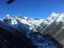
Headwall below McLennan Glacier and upper McLennan River flats
The McLennan River originates in the Premier Range, flowing from McLennan Glacier between Mount Stanley Baldwin and Mount Arthur Meighen. The river flows east out of the mountains into the Rocky Mountain Trench near Valemount. Then it turns northwest, flowing through the Rocky Mountain Trench, picking up tributary streams flowing from the Selwyn Range to the east and the Premier Range to the west. It joins the Fraser River at Tête Jaune Cache.
See also
References
- 1 2 Elevation derived from ASTER Global Digital Elevation Model, using GeoLocator, and BCGNIS coordinates.
- ↑ Derived using topographic maps and TopoQuest.
- 1 2 "McLennan River". BC Geographical Names.
- ↑ "Archived Hydrometric Data Search". Water Survey of Canada. Archived from the original on 24 December 2010. Retrieved 21 August 2013. Search for Station 08KA011 McLennan River near the mouth
This article is issued from
Wikipedia.
The text is licensed under Creative Commons - Attribution - Sharealike.
Additional terms may apply for the media files.