McClellan–Kerr Arkansas River Navigation System
| McClellan-Kerr Arkansas River Navigation System | |
|---|---|
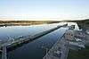
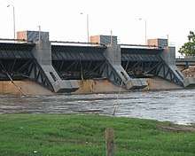
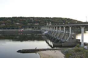 Big Dam Bridge is a footbridge built atop the Murray Lock and Dam in Little Rock, Arkansas | |
| Specifications | |
| Locks |
18 (originally 17) (Lock #11 was never constructed however Montgomery point, Lock 99, was added after construction was completed) |
| Navigation authority | Corps of Engineers |
| History | |
| Construction began | 1963 - 1971 |
| Date of first use | January 1971 |
| Date completed | 1970 |
| Geography | |
| End point | Tulsa Port of Catoosa |
| Branch(es) | Arkansas Post Canal |
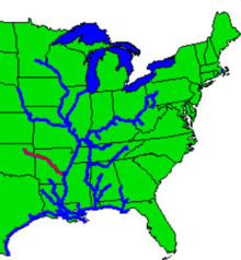
The McClellan–Kerr Arkansas River Navigation System (MKARNS) is part of the inland waterway system originating at the Tulsa Port of Catoosa and running southeast through Oklahoma and Arkansas to the Mississippi River. The system was named for two Senators: Robert S. Kerr (D-OK) and John L. McClellan (D-AR), who pushed authorizing legislation through Congress. The system officially opened June 5, 1971. President Richard M. Nixon attended the opening ceremony.[1] It is operated by the Corps of Engineers.[2]
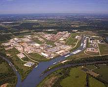
Though it primarily follows the Arkansas River, it also follows portions of the Verdigris River in Oklahoma and the White River in Arkansas. It also includes the Arkansas Post Canal, a short canal named for nearby Arkansas Post National Memorial, connecting the Arkansas and White Rivers.
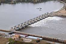
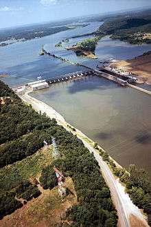
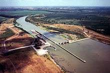
Through Oklahoma and Arkansas, dams artificially deepen and widen this modest sized river to build it into a commercially navigable body of water. The design enables traffic to overcome an elevation difference of 420 feet (130 m) between the Mississippi River and the Tulsa Port of Catoosa.[2] Along the section of the Arkansas River that carries the McClellan-Kerr channel, the river sustains commercial barge traffic and offers passenger and recreational use and is a series of reservoirs. Total length of the system is 445 miles (716 km).[1]
Official Change of Significance
The U.S. Department of Transportation (USDOT) officially announced in early May 2015 that it had upgraded MKARNS from "Connector" to "Corridor" on the National Marine Highway. The announcement also added the Oklahoma Department of Transportation (ODOT) as an official sponsor.[3][lower-alpha 1] [lower-alpha 2]
In 2015, the U. S. Army Corps of Engineers had increased its designation of the MKARNS from a moderate-use to a high-use waterway system. The high-use designation means that a waterway carries more than 10 million tons per year, having a value of more than 12 million ton-miles per year.[3]
Construction
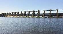
The Arkansas River is very shallow through Arkansas and Oklahoma, and was naturally incapable of supporting river traffic through most of the year. To allow for navigation, construction was started in 1963 on a system of channels and locks to connect the many reservoirs along the length of the Arkansas River. The first section, running to Little Rock, Arkansas, opened on January 1, 1969. The first barge to reach the Port of Catoosa arrived in early 1971.
Each lock measures 110 feet (34 m) wide and 600 feet (180 m) long, the standard size for much of the Mississippi River waterway. Standard jumbo barges, measuring 35 by 195 feet (59 m), are grouped 3 wide by 3 long, with a tug at center rear, to form a barge tow which can be fit into a lock. Larger barge tows must be broken down and passed through the lock in sections, and rejoined on the opposite side.[4]
The specifications for the channel itself are as follows:
- Depth of channel: 9 ft (2.7 m) or more.
- Width of channel: mostly 250 ft (76 m) to 300 ft (91 m).
- Bridge clearance: 300 ft (91 m) horizontal; 52 ft (16 m) vertical.
Although Congress originally authorized USACE to dredge the channel to a depth of 12 ft (3.7 m) in 2005, it did not provide the funds to do so. ODOT says that the capacity of each barge could be increased by 200 tons for each foot of draft.[4] An article in 2010 stated that much of MKARNS is already 12 feet (3.7 m)deep, so that only about 75 miles (121 km) would need to be deepened. The article quoted Lt. Col. Gene Snyman, then deputy commander of the U.S. Army Corps of Engineers’ Tulsa District, as saying such a project would cost about $170 million (2010 dollars).[5]
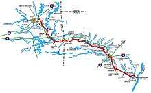
Lock information
The following tables list the features of the navigation system, from the Mississippi River to the origin at the Port of Catoosa. Except as noted, all locks are on the Arkansas River.
There is no lock 11; sequentially, it would have been in the middle of Lake Dardanelle. Per the animated system map (see "External links"), Dardanelle Lock & Dam (lock 10), which forms Lake Dardanelle, is the highest facility on the system (54 feet between upper & lower pools); Ozark-Jeta Taylor Lock & Dam (lock 12), just above that lake, is the third highest (34 feet). Thus, it is likely that those two facilities were redesigned, in terms of height and possibly location, so as to eliminate lock 11 as originally planned. The Mississippi River lock is numbered lock 99 as it was added to the system after it was completed.


.jpg)
Waterway traffic control
The growth of business along MKARNS has greatly increased congestion at the locks. The Secretary of the Army has directed the Corps of Engineers to establish the following priorities for admitting vessels to each lock:
- Vessels owned by the U.S. Government;
- Commercial vessels (e.g., barges);
There is no minimum size for watercraft using the locks. Craft as small as canoes, dinghies, kayaks have all been allowed to use the locks, either alone or with multiple other vessels at the same time.
Notes
- ↑ The Arkansas Department of Transportation had previously been designated as an official sponsor.
- ↑ According to Senator James Inhofe, (R-OK), The change of status will increase support for funding to ..."improve reliability in navigation, hydropower generation and flood risk reduction.”[3]
- ↑ The reservoir created by Ozark-Jeta Taylor Lock and Dam is named Ozark Lake.[6]
- ↑ John Paul Hammerschmidt Lake was created by the completion of James W. Trimble Lock & Dam. The lake is 26 miles (42 km) long with the dam and half its length in Arkansas and the other half of its length in Oklahoma.[6]
See also
References
- 1 2 O'Dell, Larry. Encyclopedia of Oklahoma History and Culture. "McClellan-Kerr Arkansas River Navigation System."
- 1 2 U. S. Army Corps of Engineers Little Rock District. MKARNS at the Library of Congress Web Archives (archived 2003-03-29)
- 1 2 3 ["Oklahoma Waterway Takes Prestigious Step Up in National Status (PRESS RELEASE)". U.S. Department of Transportation. May 15, 2015.] Accessed June 16, 2017.
- 1 2 "McClellan-Kerr Arkansas River Navigation System 2016 Inland Waterway Fact Sheet". Oklahoma Department of Transportation. 2016. Accessed June 16, 2017.
- ↑ Kramer, Kirk. "Going deeper – Deeper channel would boost business." Muskogee Phoenix. October 17, 2010. Accessed June 20, 2017.
- 1 2 Townsend, Jay, "11 Great Things about the Arkansas River in Arkansas." Pacesetter Live. November 17, 2015. Accessed December 21, 2017.
External links
- Map of navigation system
- History of the Arkansas River
- US Army Corps of Engineers, Little Rock, Arkansas district navigation information
- Oklahoma Digital Maps: Digital Collections of Oklahoma and Indian Territory