Mbale
| Mbale | |
|---|---|
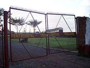
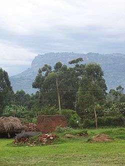 Near the grounds of Mbale Pentecostal Theological College | |
 Mbale Location in Uganda | |
| Coordinates: 01°04′50″N 34°10′30″E / 1.08056°N 34.17500°E | |
| Country |
|
| Regions | Eastern Uganda |
| Subregion | Bugisu sub-region |
| Government | |
| • Mayor | Mutwalibi Mafabi Zandya[1] |
| Elevation | 1,143 m (3,750 ft) |
| Population (2014 Census) | |
| • Total | 96,189[2] |
Mbale is a city in Eastern Region of Uganda. It is the main municipal, administrative, and commercial center of Mbale District and the surrounding sub-region.
Location
Mbale is approximately 245 kilometres (152 mi), by road, northeast of Kampala on an all weather tarmac highway.[3] The coordinates of the city are 1°04'50.0"N, 34°10'30.0"E (Latitude:1.080556; Longitude:34.175000).[4] The city also lies on the railway from Tororo to Pakwach. Mount Elgon, one of the highest peaks in East Africa, is approximately 52 kilometres (32 mi) east of Mbale.[5]
Population
According to the 2002 national census, the population of Mbale was about 71,130. In 2010, the Uganda Bureau of Statistics (UBOS) estimated the population at 81,900. In 2011, UBOS estimated the mid-year population at 91,800.[6] In 2014, the national population census put the population at 96,189.[2]
Twinning
Mbale was formally linked with the town of Pontypridd, Wales through local and regional twinning ceremonies in 2005. The link was intended to associate professionals and organizations in Pontypridd with their counterparts in Africa, under the auspices of the charity known as the Partnerships Overseas Networking Trust.[7]
Points of interest
The following points of interest lie within the city limits or close to its borders:
Administrative
- The headquarters of Mbale District Administration
- The offices of Mbale City (Municipal) Council
Public facilities
- Mbale central market
- Mbale Municipal Stadium
Military
- The headquarters of the 3rd Division of the Uganda People's Defense Force
Health facilities
- Mbale Regional Referral Hospital - A 400-bed public hospital administered by the Uganda Ministry of Health
- CURE Children's Hospital of Uganda - A 42-bed private neurosurgery hospital, owned and administered by CURE International
Educational institutions
- Busitema University Faculty of Health Sciences - The medical school of Busitema University, a public institution of higher education
- The main campus of the Islamic University in Uganda
- The Mbale Campus of Uganda Martyrs University, a private university, whose headquarters are located in Nkozi, Mpigi District.
- LivingStone International University - a private university affiliated with the fellowship of Christian Churches and Churches of Christ.
- Mbale School of Clinical Officers
Financial institutions
- PostBank Uganda
- National Social Security Fund
- Mbale Currency Center[8]
- Housing Finance Bank
- Centenary Bank
- Diamond Trust Bank (DTB)
- Barclays Bank
- Equity Bank
- DFCU Bank
Notable people
- James Wapakhabulo, politician
Nandala Mafabi, Politician
See also
References
- ↑ Mafabi, David (27 October 2013). "NRM Cadres Sabotaging Mbale Progress - Mayor". Daily Monitor. Retrieved 9 May 2014.
- 1 2 UBOS (27 August 2014). "The Population of The Regions of the Republic of Uganda And All Cities And Towns of More Than 15,000 Inhabitants". Citypopulation.de Quoting Uganda Bureau of Statistics (UBOS). Retrieved 23 February 2015.
- ↑ "Road Distance Between Kampala And Mbale With Map". Globefeed.com. Retrieved 9 May 2014.
- ↑ Google (2 July 2015). "Location of Mbale At Google Maps" (Map). Google Maps. Google. Retrieved 2 July 2015.
- ↑ "Map Showing Mbale And Mount Elgon With Route Marker". Globefeed.com. Retrieved 9 May 2014.
- ↑ "Estimated Population of Mbale In 2002, 2010 & 2011" (PDF). Uganda Bureau of Statistics. Archived from the original (PDF) on 7 July 2014. Retrieved 9 May 2014.
- ↑ "Background of Partnerships Overseas Networking Trust". Partnerships Overseas Networking Trust (PONT). Retrieved 9 May 2014.
- ↑ "Location of Mbale Currency Centre". Bank of Uganda. Retrieved 9 May 2014.
External links
| Wikivoyage has a travel guide for Mbale. |
Coordinates: 01°04′50″N 34°10′30″E / 1.08056°N 34.17500°E
Capital: Mbale | ||
| Towns and villages | 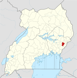 | |
| Transport | ||
| Banking |
| |
| Notable landmarks |
| |
| Education | ||
| Health | ||
| Notable people | ||
| Authority control |
|---|