Mbaitoli
| Mbaitoli | |
|---|---|
| LGA | |
 Mbaitoli | |
| Coordinates: 5°35′16″N 7°3′0″E / 5.58778°N 7.05000°E | |
| Country |
|
| State | Imo State |
| Area | |
| • Total | 79 sq mi (204 km2) |
| Population (2006) | |
| • Total | 237,555 |
| Time zone | UTC+1 (WAT) |
Mbaitoli is a Local Government Area of Imo State, Nigeria. Its headquarters are in the town of Nwaorieubi (or Nworieubi).
It has an area of 204 km² and a population of 237,555 at the 2006 census, although the state government claims 234 km² and a 2004 population of 255,000.[1] The postal code of the area is 461.[2] Mbaitoli is divided into 9 autonomous communities with 12 INEC wards. The principal occupations of these communities are farming and crafts such as basket making, broom making, and hair weaving etc.[1]
Communities and villages
References
- 1 2 "Mbaitoli". Imo State Government. Retrieved 10 September 2014.
- ↑ "Post Offices- with map of LGA". NIPOST. Archived from the original on November 26, 2012. Retrieved 2009-10-20.
State capital: Owerri | ||
| Local Government Areas | 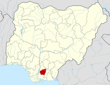 | |
This article is issued from
Wikipedia.
The text is licensed under Creative Commons - Attribution - Sharealike.
Additional terms may apply for the media files.