Mayer State Park
| Mayer State Park | |
|---|---|
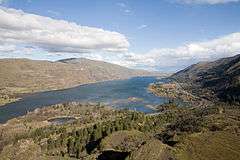 View east of the Columbia River from Rowena Crest | |
 | |
| Type | Public, state |
| Location | Wasco County, Oregon |
| Nearest city | The Dalles |
| Coordinates | 45°40′32″N 121°16′11″W / 45.675676°N 121.2697945°WCoordinates: 45°40′32″N 121°16′11″W / 45.675676°N 121.2697945°W[1] |
| Operated by | Oregon Parks and Recreation Department |
Mayer State Park is a state park in the Columbia River Gorge, near Rowena, Oregon in Wasco County in the U.S. state of Oregon. It consists of several disjointed parcels of transected by Interstate 84 and the tracks of the Union Pacific Railroad.
The south-easternmost parcel includes the Rowena Loops, a series of horseshoe curves by which the Historic Columbia River Highway (U.S. Route 30) climbs to the Rowena Crest, where there is an overlook, from the community of Rowena.
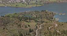 The lower portion of the park includes a small lake, boat ramp, and the Rowena Loops of the Historic Columbia River Highway. |
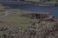 The upper portion of the park includes Rowena Crest, a viewpoint with interpretive signs, and Rowena Plateau. |
References
- ↑ "Mayer State Park". Geographic Names Information System. United States Geological Survey. Retrieved 2011-07-01.
External links

- "Mayer State Park". Oregon State Parks and Recreation. Retrieved 2011-07-01.
This article is issued from
Wikipedia.
The text is licensed under Creative Commons - Attribution - Sharealike.
Additional terms may apply for the media files.