Mattwaldhorn
| Mattwaldhorn | |
|---|---|
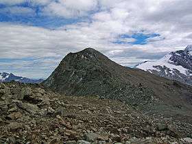 View of the Mattwaldhorn with the Senggchuppa on the right | |
| Highest point | |
| Elevation | 3,246 m (10,650 ft) |
| Prominence | 223 m (732 ft) [1] |
| Parent peak | Weissmies |
| Coordinates | 46°11′55.5″N 7°57′15.6″E / 46.198750°N 7.954333°ECoordinates: 46°11′55.5″N 7°57′15.6″E / 46.198750°N 7.954333°E |
| Geography | |
 Mattwaldhorn Location in Switzerland | |
| Location | Valais, Switzerland |
| Parent range | Pennine Alps |
The Mattwaldhorn is a mountain of the Swiss Pennine Alps, located between the upper Nanztal and the Saastal in the canton of Valais. The nearest locality is Eisten on the west side.
References
External links
This article is issued from
Wikipedia.
The text is licensed under Creative Commons - Attribution - Sharealike.
Additional terms may apply for the media files.