Mattmarksee
| Mattmark dam | |
|---|---|
 | |
| Location | Saas Valley, Valais |
| Coordinates | 46°2′17″N 7°57′36″E / 46.03806°N 7.96000°ECoordinates: 46°2′17″N 7°57′36″E / 46.03806°N 7.96000°E |
| Type | reservoir |
| Catchment area | 37.10 km2 (14.32 sq mi) |
| Basin countries | Switzerland |
| Max. length | 3.2 km (2.0 mi) |
| Surface area | 1.76 km2 (0.68 sq mi) |
| Max. depth | 93 m (305 ft) |
| Water volume | 10.5 million cubic metres (8,500 acre⋅ft) |
| Surface elevation | 2,197 m (7,208 ft) |
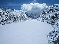
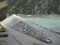
Mattmark dam is a reservoir in the Saas Valley of the Canton of Valais, Switzerland. The Mattmark dam was built from 1960-1965. The lake's surface area is 1.76 km2 (0.68 sq mi).
The lake lies at a height of 2,197 metres above sea level, between the massifs of the Rimpfischhorn and Stellihorn. The highest peak visible from the lake is the Strahlhorn (4,190 m).
Mattmark dam
External links
- Kraftwerke Mattmark (in German) (in French)
- Images

This article is issued from
Wikipedia.
The text is licensed under Creative Commons - Attribution - Sharealike.
Additional terms may apply for the media files.