Matthew Henson State Park
| Matthew Henson State Park | |
| Matthew Henson Trail | |
| Maryland State Park | |
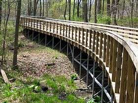 Boardwalk section of Matthew Henson Trail | |
| Country | United States |
|---|---|
| State | Maryland |
| County | Montgomery |
| Coordinates | 39°04′40″N 77°03′53″W / 39.07778°N 77.06472°WCoordinates: 39°04′40″N 77°03′53″W / 39.07778°N 77.06472°W |
| Trail length | 4.5 mi (7 km) |
| Area | 100 acres (40 ha) [1] |
| Established | 1989 |
| Management | Montgomery County Department of Parks |
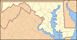 Location in Maryland | |
| Website: Matthew Henson Trail | |
Matthew Henson State Park is a publicly owned greenway with recreational features that runs along Turkey Branch, a tributary of Rock Creek, in Montgomery County, Maryland.[2] The state park is managed by Montgomery County under an agreement with the Maryland Department of Natural Resources.[3] It was named for Maryland native and arctic explorer Matthew Henson.[4]
Matthew Henson Trail, an 8-foot-wide (2.4 m) hard surface hiking/biking trail, was completed through the park in 2009.[4] The trail runs 4.5 miles (7.2 km) from the Rock Creek Hiker-Biker Trail near Aspen Hill northeast to Alderton Road near Layhill. The trail features 0.6 miles (0.97 km) of wooden boardwalk through environmentally sensitive areas.[5]
History
Purchased by the state in the 1950s,[6] the land was originally called the Rockville Facility, which would have connected to Montrose Parkway[5] as a spur to the proposed Washington Outer Beltway.[4] In response to residents' calls to the preserve the stream valley corridor, the state legislature designated 83 acres of the land as a state park and 117 acres as a county park in 1989.[7][8] The state land is owned by the Maryland Department of Natural Resources, and the county land is owned by the Maryland-National Capital Park and Planning Commission (M-NCPPC).[7]
Planning for the Matthew Henson Trail began in 2001. After many public meetings and environmental studies, the trail's preliminary plan was approved by the Montgomery County Planning Board in 2003.[7] Funding was put forth in 2006.[9] The Montgomery County Department of Transportation paid for the design and construction, but the M-NCPPC managed the project.[7] Opened May 9, 2009,[4] the project cost $5.7 million.[7] The trail connects with the Rock Creek Hiker-Biker Trail at Winding Creek Local Park on Dewey Road and continues northeast to Alderton Road.[10][11] The trail includes ten-foot-wide boardwalks to protect the most sensitive areas and solar-powered emergency cellular phones. The trail's design and construction were nominated for a Planning & Design Award as part of the 2010 National Trails Awards.[7]
References
- ↑ "Fiscal Year 2016 DNR Owned Lands Acreage" (PDF). Maryland Department of Natural Resources. July 29, 2016. Retrieved November 5, 2017.
- ↑ "Montgomery County Parks". Rock Creek Conservancy. Retrieved July 17, 2015.
- ↑ "Montgomery County". Maryland Atlas of Greenways, Water Trails, and Green Infrastructure. Maryland Department of Natural Resources. Archived from the original on February 8, 2007. Retrieved June 24, 2011.
- 1 2 3 4 Brachfeld, Melissa J. (May 6, 2009). "Matthew Henson hiker-biker trail to open Saturday". The Gazette. Gaithersburg, Md. Retrieved January 1, 2014.
- 1 2 Bathen, Effie (January 8, 2003). "Matthew Henson trail construction takes political turn". The Gazette. Gaithersburg, Md. Retrieved June 1, 2013.
- ↑ Townsend, Eric J.S. (March 4, 2003). "Bike trail proposal detoured by senate delegation". Capital News Service. Maryland Newsline. Archived from the original on September 12, 2006. Retrieved July 17, 2015.
- 1 2 3 4 5 6 "Design and Construction of the Matthew Henson State Park". American Trails. Retrieved June 1, 2013.
- ↑ "Code of Maryland, Courts and Judicial Proceedings Sec. 5-10004". General Assembly of Maryland. Retrieved 11 December 2017.
- ↑ "Matthew Henson Trail: No. 500400" (PDF). Montgomery County. May 18, 2006. Retrieved June 1, 2013.
- ↑ "Matthew Henson Trail". Montgomery County Parks. August 24, 2016. Retrieved November 5, 2017.
- ↑ "Matthew Henson Trail" (PDF). M-NCPPC. Retrieved July 17, 2015.
External links
| Wikimedia Commons has media related to Matthew Henson State Park. |
- Matthew Henson Trail Montgomery County Department of Parks
- Matthew Henson Trail Map Montgomery County Department of Parks