Mathiang, South Sudan
| Mathiang Mathiaŋ | |
|---|---|
| boma village | |
 Mathiang | |
| Coordinates: 6°25′46″N 31°34′57″E / 6.42944°N 31.58250°ECoordinates: 6°25′46″N 31°34′57″E / 6.42944°N 31.58250°E | |
| Country | South Sudan |
| State | Jonglei State |
| County | Bor West County (since 2016) [1] |
| Payam | Baidit |
Mathiang is a boma in Baidit payam, Bor West County, Jonglei State, South Sudan, about 30 kilometers north of Bor. The village is located at the southern extent of the sudd, South Sudan's central wetlands, on the east side of the Bahr al Jabal River.
Demographics
According to the Fifth Population and Housing Census of Sudan, conducted in April 2008, Mathiang boma had a population of 8,949 people, composed of 4,469 male and 4,480 female residents.[2][note 1]
Notes
- ↑ In 2008, at the time of the census, Mathiang was located in Bor South County. The data collected during the Fifth Population and Housing Census of Sudan were to be the primary source of information for decisions about the number and demarcation of electoral constituencies and administrative boundaries in what was then southern Sudan. South Sudanese officials rejected census results for southern Sudan. See Darfur Relief and Documentation Centre (2010). 5th Population and Housing Census in Sudan – An Incomplete Exercise (PDF) (Report). Darfur Relief and Documentation Centre, Geneva (Switzerland). Retrieved June 11, 2017. . Also, see Demographics of South Sudan.
References
- ↑ Mading, Juuk Othana (May 3, 2016). "Governor Establishes Additional Counties In Jonglei". Gurtong. Bor, South Sudan. Retrieved June 12, 2017.
- ↑ National Bureau of Statistics (2013). Population Distribution by Sex by Boma, Vol. III (Report). The Republic of South Sudan, The National Bureau of Statistics. p. 34. Retrieved June 11, 2017.
Table 138: Jonglei State, Bor South County, Baidit Payam
State capital: Bor | ||
| Populated places | 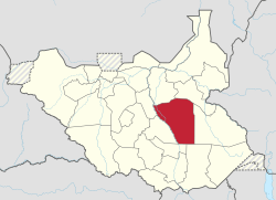 | |
| Universities | ||
| Airports | ||
| Other | ||
This article is issued from
Wikipedia.
The text is licensed under Creative Commons - Attribution - Sharealike.
Additional terms may apply for the media files.