Matanuska Glacier
| Matanuska Glacier | |
|---|---|
 Matanuska Glacier | |
 | |
| Type | Mountain glacier |
| Coordinates | 61°39′21″N 147°34′52″W / 61.65583°N 147.58111°WCoordinates: 61°39′21″N 147°34′52″W / 61.65583°N 147.58111°W |
| Length | 27 miles (43 km) [1] |
| Terminus | Matanuska River |
| Status | Retreating |
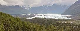
Matanuska Glacier is a valley glacier in the US state of Alaska. At 27 miles (43 km) long by 4 miles (6.4 km) wide, it is the largest glacier accessible by car in the United States. Its terminus feeds the Matanuska River.[2] It lies near the Glenn Highway about 100 miles (160 km) north-east of Anchorage. Matanuska Glacier flows about 1 foot (30 cm) per day. Due to ablation of the lower glacier, as of 2007, the location of the glacier terminus changed little over the previous three decades.[3]
The glacier is the eponym of the Alaska Marine Highway ferry M/V Matanuska.
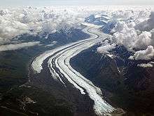
Matanuska Glacier from 20,000 feet (6,100 m)
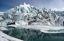
Matanuska Glacier terminus
See also
References
| Wikimedia Commons has media related to Matanuska Glacier. |
This article is issued from
Wikipedia.
The text is licensed under Creative Commons - Attribution - Sharealike.
Additional terms may apply for the media files.