Christ's Hospital of Abingdon
Christ's Hospital of Abingdon is a charity with a long history, based in Abingdon, Oxfordshire, (formerly Berkshire), England.[2]
A royal charter established the Master and Governors of the Hospital of Christ of Abingdon in 1553, the year that Mary I succeeded to the English throne. Sir John Mason, a Tudor diplomat, was its first Master from 1553 to 1566.
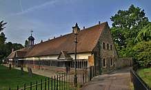
The charity supports almshouses in Abingdon.[1] Sampson Strong decorated the hall with portraits of founders, benefactors and former governors.[3]
The charity has been involved with education, educating Abingdon boys from 1608 until 1870. There has been a close connection with Abingdon School since 1870.[4]

Christ's Hospital established Albert Park in northwest Abingdon (west of Abingdon School) in the 1860s on the site of the former Conduit Field.[5]
The current charity is based at 1 Old Station Road in Abingdon, Registered Charity Number 205112.[6]
See also
- Thomas Tesdale, who served as Master of Christ's Hospital
- List of almshouses in the United Kingdom
References
- 1 2 "Almshouses". Christ's Hospital of Abingdon. Archived from the original on 26 March 2011. Retrieved 7 April 2011.
- ↑ "History". Christ's Hospital of Abingdon. Archived from the original on 26 March 2011. Retrieved 7 April 2011.
- ↑ Girouard, Mark (1990). The English Town: A History of Urban Life. New Haven: Yale University Press. p. 58. ISBN 0-300046359.
- ↑ "Christ's Hospital Arms". Abingdon School. Retrieved 7 April 2011.
- 1 2 "Albert Park". Christ's Hospital of Abingdon. Archived from the original on 26 March 2011. Retrieved 7 April 2011.
- ↑ "Christ's Hospital of Abingdon". CharitiesDirect.com. Archived from the original on 23 July 2012. Retrieved 7 April 2011.
External links
- Christ's Hospital of Abingdon
- Haval, Nikhilesh. "Long Alley Almshouse". Oxfordshire in 360 degrees. Nikreations.
- Haval, Nikhilesh. "Mr Twitty's Almshouse". Oxfordshire in 360 degrees. Nikreations.