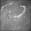
Maskelyne (crater)
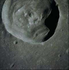 Apollo 10 Hasselblad Camera image | |
| Coordinates | 2°12′N 30°06′E / 2.2°N 30.1°ECoordinates: 2°12′N 30°06′E / 2.2°N 30.1°E |
|---|---|
| Diameter | 24 km |
| Depth | 2.5 km |
| Colongitude | 330° at sunrise |
| Eponym | Nevil Maskelyne |
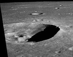
Maskelyne is a solitary lunar impact crater that lies in the southeast part of the Mare Tranquillitatis. The outer rim has a somewhat polygonal shape, although it is generally circular. The inner walls are terraced and there is a low central rise at the midpoint of the floor.
Its diameter is 24 km long and is 2,500 meters deep. The area is around 450 km² and the perimeter is about 75 km.
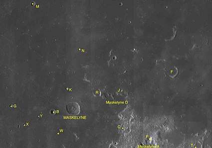
The landing site of the Apollo 11 expedition is located about 250 kilometers to the west-southwest. To the northeast are Wallach and Aryabhata, under 150 km west is the ghost crater Lamont, and to the southeast is the bright Censorinus. To the south are the lunar mountains informally known as Duke Island and Boot Hill. There are sinuous rilles southwest and west of Maskelyne - these were informally named Sidewinder and Diamondback by the Apollo 10 crew[1] and referred to as such by later missions, especially Apollo 11.
From that location the Earth would appear in the lunar sky at over 30 degrees from the top towards the west and 2 degrees to the left.
Satellite craters
By convention these features are identified on lunar maps by placing the letter on the side of the crater midpoint that is closest to Maskelyne.
| Maskelyne | Latitude | Longitude | Diameter |
|---|---|---|---|
| A | 0.1° N | 34.0° E | 29 km |
| B | 2.0° N | 28.9° E | 9 km |
| C | 1.1° N | 32.7° E | 9 km |
| D | 2.5° N | 32.5° E | 33 km |
| F | 4.2° N | 35.3° E | 21 km |
| G | 2.4° N | 26.7° E | 6 km |
| J | 3.2° N | 32.7° E | 4 km |
| K | 3.3° N | 29.6° E | 5 km |
| M | 7.8° N | 27.9° E | 8 km |
| N | 5.4° N | 30.3° E | 5 km |
| P | 0.5° N | 34.1° E | 10 km |
| R | 3.0° N | 31.3° E | 13 km |
| T | 0.0° S | 36.6° E | 5 km |
| W | 0.9° N | 29.2° E | 4 km |
| X | 1.3° N | 27.4° E | 4 km |
| Y | 1.8° N | 28.1° E | 4 km |
The following craters have been renamed by the IAU.
- Maskelyne E — See Aryabhata (crater).
- Maskelyne H — See Wallach (crater).
References
- ↑ Apollo 10 Flight Journal, Part 19, We is down among them, Corrected Transcript and Commentary by David Woods, Robin Wheeler, and Ian Roberts. Last update: 2017-02-10
- Andersson, L. E.; Whitaker, E. A. (1982). NASA Catalogue of Lunar Nomenclature. NASA RP-1097.
- Blue, Jennifer (July 25, 2007). "Gazetteer of Planetary Nomenclature". USGS. Retrieved 2007-08-05.
- Bussey, B.; Spudis, P. (2004). The Clementine Atlas of the Moon. New York: Cambridge University Press. ISBN 978-0-521-81528-4.
- Cocks, Elijah E.; Cocks, Josiah C. (1995). Who's Who on the Moon: A Biographical Dictionary of Lunar Nomenclature. Tudor Publishers. ISBN 978-0-936389-27-1.
- McDowell, Jonathan (July 15, 2007). "Lunar Nomenclature". Jonathan's Space Report. Retrieved 2007-10-24.
- Menzel, D. H.; Minnaert, M.; Levin, B.; Dollfus, A.; Bell, B. (1971). "Report on Lunar Nomenclature by the Working Group of Commission 17 of the IAU". Space Science Reviews. 12 (2): 136–186. Bibcode:1971SSRv...12..136M. doi:10.1007/BF00171763.
- Moore, Patrick (2001). On the Moon. Sterling Publishing Co. ISBN 978-0-304-35469-6.
- Price, Fred W. (1988). The Moon Observer's Handbook. Cambridge University Press. ISBN 978-0-521-33500-3.
- Rükl, Antonín (1990). Atlas of the Moon. Kalmbach Books. ISBN 978-0-913135-17-4.
- Webb, Rev. T. W. (1962). Celestial Objects for Common Telescopes (6th revised ed.). Dover. ISBN 978-0-486-20917-3.
- Whitaker, Ewen A. (1999). Mapping and Naming the Moon. Cambridge University Press. ISBN 978-0-521-62248-6.
- Wlasuk, Peter T. (2000). Observing the Moon. Springer. ISBN 978-1-85233-193-1.
External links
| Wikimedia Commons has media related to Maskelyne (crater). |
- LTO-61D4 Maskelyne Orientalis, Lunar Topographic Orthophotomap (LTO) Series
- Location of Maskelyne Crater in Google Moon