Maryland Route 614
| ||||
|---|---|---|---|---|
| Goldsboro Road | ||||
 | ||||
| Route information | ||||
| Maintained by MDSHA | ||||
| Length | 1.97 mi[1] (3.17 km) | |||
| Existed | 1935 – present | |||
| Major junctions | ||||
| South end | MacArthur Boulevard in Glen Echo | |||
| North end |
| |||
| Location | ||||
| Counties | Montgomery | |||
| Highway system | ||||
| ||||

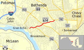
Maryland Route 614 (MD 614) is a state highway in the U.S. state of Maryland. Known as Goldsboro Road, the state highway runs 1.97 miles (3.17 km) from MacArthur Boulevard in Glen Echo north to MD 191 in Bethesda in southwestern Montgomery County. MD 614 was constructed in the mid-1930s from MD 396 to MD 190. The highway was extended to its present termini in the late 1970s.
Route description
_at_MacArthur_Boulevard_in_Brookmont%2C_Montgomery_County%2C_Maryland.jpg)
MD 614 begins at a directional intersection with MacArthur Boulevard in Glen Echo adjacent to the entrance to the Clara Barton National Historic Site and Glen Echo Park. The state highway heads northeast as a two-lane highway that parallels Minnehaha Branch. MD 614 passes the western terminus of MD 396 (Massachusetts Avenue) before temporarily widening to a four-lane divided highway on either side of its intersection with MD 190 (River Road). MD 614 continues east, passing through Kenwood Country Club before reaching its northern terminus at MD 191 (Bradley Boulevard) in Bethesda.[1][2]
History
MD 614 west of MD 396 was built as part of that highway; the concrete road was constructed in 1934 and 1935.[3][4] MD 614 from MD 396 to MD 190 was built as a concrete road in 1935.[4] In 1978, the state highway was extended west over MD 396 to MacArthur Boulevard and east from MD 190 to MD 191.[5] The MD 396–MD 614 intersection was originally a wye; the junction was changed to its current T intersection by 1999.[6][7]
Junction list
The entire route is in Montgomery County.
| Location | mi[1] | km | Destinations | Notes | |
|---|---|---|---|---|---|
| Glen Echo | 0.00 | 0.00 | MacArthur Boulevard – Cabin John, Washington | Southern terminus | |
| Bethesda | 0.46 | 0.74 | Western terminus of MD 396 | ||
| 1.04 | 1.67 | ||||
| 1.97 | 3.17 | Northern terminus | |||
| 1.000 mi = 1.609 km; 1.000 km = 0.621 mi | |||||
Auxiliary routes
MD 614 has four auxiliary routes. All four are 0.02-mile (0.032 km) right-turn ramps at the state highway's intersection with MD 190.
- MD 614A is the ramp from eastbound MD 190 to southbound MD 614.
- MD 614B is the ramp from southbound MD 614 to westbound MD 190.
- MD 614C is the ramp from westbound MD 190 to northbound MD 614.
- MD 614D is the ramp from northbound MD 614 to eastbound MD 190.[1]
The four auxiliary routes were assigned to the four ramps by 1999.[7]
See also

References
- 1 2 3 4 Highway Information Services Division (December 31, 2013). Highway Location Reference. Maryland State Highway Administration. Retrieved 2013-09-01.
- Montgomery County (PDF)
- ↑ Google (2010-08-02). "Maryland Route 614" (Map). Google Maps. Google. Retrieved 2010-08-02.
- ↑ Byron, William D.; Lacy, Robert (December 28, 1934). Report of the State Roads Commission of Maryland (1931–1934 ed.). Baltimore: Maryland State Roads Commission. pp. 35, 49. Retrieved 2013-08-26.
- 1 2 Maryland Geological Survey (1935). Map of Maryland Showing State Road System: State Aid Roads and Improved County Road Connections (Map). Baltimore: Maryland Geological Survey.
- ↑ Maryland State Highway Administration (1978). Maryland: Official Highway Map (Map). Baltimore: Maryland State Highway Administration.
- ↑ Falls Church, VA quadrangle (Map) (1965 ed.). 1:24,000. 7 1/2 Minute Series (Topographic). United States Geological Survey.
- 1 2 Highway Information Services Division (December 31, 1999). Highway Location Reference. Maryland State Highway Administration. Retrieved 2013-09-01.
- Montgomery County (PDF)
External links
| Wikimedia Commons has media related to Maryland Route 614. |
Route map: