Maryland Route 594
| ||||
|---|---|---|---|---|
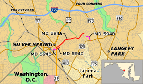 Collection of MD 594's routes highlighted in red and magenta | ||||
| Route information | ||||
| Maintained by MDSHA | ||||
| Length | 1.40 mi[1] (2.25 km) | |||
| Existed | 2016 – present | |||
| Major junctions | ||||
| West end |
| |||
| East end | Flower Avenue in Silver Spring | |||
| Location | ||||
| Counties | Montgomery | |||
| Highway system | ||||
| ||||

Maryland Route 594 (MD 594) is an unsigned state highway in the U.S. state of Maryland. Known as Wayne Avenue, the highway runs 1.40 miles (2.25 km) from U.S. Route 29 (US 29) east to Flower Avenue within Silver Spring in southeastern Montgomery County. This segment is part of a collection of four auxiliary routes designated as MD 594 in the Silver Spring area.
Route description
_at_U.S._Route_29_(Georgia_Avenue)_in_Silver_Spring%2C_Montgomery_County%2C_Maryland.jpg)
MD 594 (officially MD 594A) begins at the intersection of US 29 (Georgia Avenue) and Wayne Avenue in downtown Silver Spring. Wayne Avenue continues west as a county highway toward the Silver Spring Transit Center and MD 384 (Colesville Road). MD 594 heads northeast as a four-lane divided highway to Fenton Street, where the highway passes the Silver Spring Library. The highway continues east as a four-lane undivided highway out of downtown Silver Spring. MD 594 descends into the valley of Sligo Creek and intersects Dale Drive, at the corner of which the highway passes Silver Spring International Middle School, which inhabits the former campus of Montgomery Blair High School. The highway intersects Sligo Creek Parkway immediately after it crosses Sligo Creek. MD 594 ascends from the stream valley as a two-lane street to its eastern terminus at Flower Avenue. Wayne Avenue continues east to a dead end at Long Branch, a tributary of Sligo Creek.[1][2]
History
MD 594A, MD 594B, MD 594C, and MD 594D were transferred to the state from Montgomery County on March 15, 2016.[1]
Junction list
The entire route is in Silver Spring, Montgomery County.
| mi[1] | km | Destinations | Notes | ||
|---|---|---|---|---|---|
| 0.00 | 0.00 | Western terminus | |||
| 1.02 | 1.64 | Sligo Creek Parkway | |||
| 1.40 | 2.25 | Flower Avenue / Wayne Avenue east | Eastern terminus | ||
| 1.000 mi = 1.609 km; 1.000 km = 0.621 mi | |||||
Auxiliary routes
MD 594 has three auxiliary routes, all of which were established at the same time as the Wayne Avenue portion of the highway in 2016.[1]
- MD 594B is the designation for the 0.13-mile-long (0.21 km) section of Bonifant Street from Ramsey Avenue, which borders the Silver Spring Transit Center, to US 29 (Georgia Avenue) in downtown Silver Spring.[1][2]
- MD 594C is the designation for the 0.16-mile-long (0.26 km) section of Bonifant Street from US 29 to Fenton Street on the opposite side of the Silver Spring Library from Wayne Avenue in downtown Silver Spring. Bonifant Street continues east as a county-maintained street.[1][2]
- MD 594D is the designation for Arliss Street, which runs 0.27 miles (0.43 km) from Flower Avenue south of its intersection with Wayne Avenue east and south to MD 320 (Piney Branch Road).[1][2]
See also

References
- 1 2 3 4 5 6 7 8 Highway Information Services Division (December 31, 2015). Highway Location Reference. Maryland State Highway Administration. Retrieved August 9, 2016.
- Montgomery County (PDF)
- 1 2 3 4 Maryland State Highway Administration (2015). Maryland General Highway Statewide Grid Map (PDF) (Map). 1:12,000. Baltimore: Maryland State Highway Administration. § F11A. Retrieved August 9, 2016.
External links
| Wikimedia Commons has media related to Maryland Route 594. |
Route map: