Mary Esther, Florida
| Mary Esther, Florida | |
|---|---|
| City | |
 Mary Esther City Hall, September 2014. | |
| Motto(s): "A Growing Community " | |
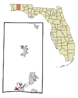 Location in Okaloosa County and the state of Florida | |
| Coordinates: 30°24′44″N 86°39′33″W / 30.41222°N 86.65917°WCoordinates: 30°24′44″N 86°39′33″W / 30.41222°N 86.65917°W | |
| Country |
|
| State |
|
| County | Okaloosa |
| Government | |
| • Type | Municipality |
| • Mayor | Christopher Stein |
| • Mayor Pro Tem | Danny Bennett |
| • Councilmember | Ron Sterns |
| • Councilmember | James W. Kitchens, Jr. |
| • Councilmember | Charlotte McKamy |
| Area[1] | |
| • Total | 1.48 sq mi (3.83 km2) |
| • Land | 1.47 sq mi (3.81 km2) |
| • Water | 0.01 sq mi (0.02 km2) |
| Elevation | 23 ft (7 m) |
| Population (2010) | |
| • Total | 3,851 |
| • Estimate (2016)[2] | 4,289 |
| • Density | 2,913.72/sq mi (1,124.67/km2) |
| Time zone | UTC-6 (Central (CST)) |
| • Summer (DST) | UTC-5 (CDT) |
| ZIP code | 32569 |
| Area code(s) | 850 |
| FIPS code | 12-43375[3] |
| GNIS feature ID | 0286480[4] |
Mary Esther is a city in Okaloosa County, Florida, United States. The population was 3,851 at the 2010 census. It is part of the Fort Walton Beach–Crestview–Destin Metropolitan Statistical Area.
Etymology
Mary Esther gets its name from its first postmaster, John Newton, who named it for his daughters.[5]
Geography
Mary Esther is located at 30°24′44″N 86°39′33″W / 30.412266°N 86.659044°W.[6]
According to the United States Census Bureau, the city has a total area of 1.5 square miles (3.9 km2), all land.
Climate
Climate is characterized by relatively high temperatures and evenly distributed precipitation throughout the year. This climate type is found on the eastern sides of the continents between 20° and 35° N and S latitude. The Köppen Climate Classification subtype for this climate is "Cfa" (Humid Subtropical Climate).[7]
Demographics
| Historical population | |||
|---|---|---|---|
| Census | Pop. | %± | |
| 1950 | 332 | — | |
| 1960 | 780 | 134.9% | |
| 1970 | 3,192 | 309.2% | |
| 1980 | 3,530 | 10.6% | |
| 1990 | 4,139 | 17.3% | |
| 2000 | 4,055 | −2.0% | |
| 2010 | 3,851 | −5.0% | |
| Est. 2016 | 4,289 | [2] | 11.4% |
| U.S. Decennial Census[8] | |||
As of the census[3] of 2000, there were 4,055 people, 1,623 households, and 1,147 families residing in the city. The population density was 2,635.0 inhabitants per square mile (1,016.7/km²). There were 1,732 housing units at an average density of 1,125.5 per square mile (434.2/km²). The racial makeup of the city was 83.65% White, 6.46% African American, 0.96% Native American, 3.77% Asian, 0.17% Pacific Islander, 1.21% from other races, and 3.77% from two or more races. Hispanic or Latino of any race were 4.09% of the population.
There were 1,623 households out of which 29.0% had children under the age of 18 living with them, 57.0% were married couples living together, 9.9% had a female householder with no husband present, and 29.3% were non-families. 21.7% of all households were made up of individuals and 7.0% had someone living alone who was 65 years of age or older. The average household size was 2.50 and the average family size was 2.93.
In the city, the population was spread out with 23.4% under the age of 18, 7.8% from 18 to 24, 30.5% from 25 to 44, 25.1% from 45 to 64, and 13.3% who were 65 years of age or older. The median age was 39 years. For every 100 females, there were 102.3 males. For every 100 females age 18 and over, there were 100.1 males.
The median income for a household in the city was $42,647, and the median income for a family was $47,917. Males had a median income of $31,030 versus $20,319 for females. The per capita income for the city was $22,488. About 4.1% of families and 5.7% of the population were below the poverty line, including 8.8% of those under age 18 and 1.0% of those age 65 or over.
References
- ↑ "2016 U.S. Gazetteer Files". United States Census Bureau. Retrieved Jul 7, 2017.
- 1 2 "Population and Housing Unit Estimates". Retrieved June 9, 2017.
- 1 2 "American FactFinder". United States Census Bureau. Retrieved 2008-01-31.
- ↑ "US Board on Geographic Names". United States Geological Survey. 2007-10-25. Retrieved 2008-01-31.
- ↑ "City of Mary Esther, Florida - About Us". www.cityofmaryesther.com. Retrieved 1 May 2018.
- ↑ "US Gazetteer files: 2010, 2000, and 1990". United States Census Bureau. 2011-02-12. Retrieved 2011-04-23.
- ↑ "Mary Esther, Florida Köppen Climate Classification (Weatherbase)". Weatherbase. Retrieved 1 May 2018.
- ↑ "Census of Population and Housing". Census.gov. Archived from the original on May 12, 2015. Retrieved June 4, 2015.
External links
Municipalities and communities of Okaloosa County, Florida, United States | ||
|---|---|---|
| Cities |  | |
| Towns | ||
| CDPs | ||
| Unincorporated communities | ||
| Ghost towns | ||
| Authority control |
|---|