Marion, Michigan
| Marion, Michigan | |
|---|---|
| Village | |
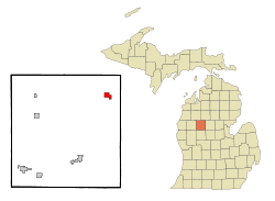 Location of Marion, Michigan | |
| Coordinates: 44°6′10″N 85°8′49″W / 44.10278°N 85.14694°W | |
| Country | United States |
| State | Michigan |
| County | Osceola |
| Government | |
| • Mayor | Camren M. Turner |
| Area[1] | |
| • Total | 1.39 sq mi (3.60 km2) |
| • Land | 1.35 sq mi (3.50 km2) |
| • Water | 0.04 sq mi (0.10 km2) |
| Elevation | 1,099 ft (335 m) |
| Population (2010)[2] | |
| • Total | 872 |
| • Estimate (2016)[3] | 853 |
| • Density | 630/sq mi (240/km2) |
| Time zone | UTC-5 (Eastern (EST)) |
| • Summer (DST) | UTC-4 (EDT) |
| ZIP code | 49665 |
| Area code(s) | 231 |
| FIPS code | 26-51660[4] |
| GNIS feature ID | 0631557[5] |
Marion is a village in Osceola County in the U.S. state of Michigan. The population was 872 at the 2010 census. The village is located within Marion Township. It is the home of Alma College Football player, Camren Turner.
Geography
According to the United States Census Bureau, the village has a total area of 1.39 square miles (3.60 km2), of which 1.35 square miles (3.50 km2) is land and 0.04 square miles (0.10 km2) is water.[1]
History
Marion was named after Marion Clark. She and her husband Christopher settled in the area and began a logging camp with a saw mill. The Clarks also started a general store, delivered mail, and taught school.
Demographics
| Historical population | |||
|---|---|---|---|
| Census | Pop. | %± | |
| 1900 | 741 | — | |
| 1910 | 767 | 3.5% | |
| 1920 | 708 | −7.7% | |
| 1930 | 607 | −14.3% | |
| 1940 | 710 | 17.0% | |
| 1950 | 879 | 23.8% | |
| 1960 | 898 | 2.2% | |
| 1970 | 891 | −0.8% | |
| 1980 | 816 | −8.4% | |
| 1990 | 807 | −1.1% | |
| 2000 | 836 | 3.6% | |
| 2010 | 872 | 4.3% | |
| Est. 2016 | 853 | [3] | −2.2% |
| U.S. Decennial Census[6] | |||
2010 census
As of the census[2] of 2010, there were 872 people, 351 households, and 234 families residing in the village. The population density was 645.9 inhabitants per square mile (249.4/km2). There were 389 housing units at an average density of 288.1 per square mile (111.2/km2). The racial makeup of the village was 98.3% White, 0.1% African American, 0.5% Native American, 0.1% from other races, and 1.0% from two or more races. Hispanic or Latino of any race were 1.3% of the population.
There were 351 households of which 36.5% had children under the age of 18 living with them, 45.6% were married couples living together, 14.2% had a female householder with no husband present, 6.8% had a male householder with no wife present, and 33.3% were non-families. 28.2% of all households were made up of individuals and 15.3% had someone living alone who was 65 years of age or older. The average household size was 2.48 and the average family size was 2.97.
The median age in the village was 37.4 years. 27.4% of residents were under the age of 18; 8.3% were between the ages of 18 and 24; 22.9% were from 25 to 44; 24.5% were from 45 to 64; and 16.7% were 65 years of age or older. The gender makeup of the village was 47.1% male and 52.9% female.
2000 census
As of the census[4] of 2000, there were 836 people, 352 households, and 229 families residing in the village. The population density was 617.5 per square mile (239.1/km²). There were 388 housing units at an average density of 286.6 per square mile (111.0/km²). The ethnic makeup of the village was 97.97% White, 0.12% African American, 0.48% Native American, 0.12% Asian, 0.12% from other races, and 1.20% from two or more races. Hispanic or Latino of any race were 0.96% of the population.
There were 352 households out of which 33.8% had children under the age of 18 living with them, 48.3% were married couples living together, 11.9% had a female householder with no husband present, and 34.7% were non-families. 31.0% of all households were made up of individuals and 13.9% had someone living alone who was 65 years of age or older. The average household size was 2.38 and the average family size was 2.93.
In the village, the population was spread out with 27.3% under the age of 18, 9.3% from 18 to 24, 26.9% from 25 to 44, 21.2% from 45 to 64, and 15.3% who were 65 years of age or older. The median age was 36 years. For every 100 females, there were 94.9 males. For every 100 females age 18 and over, there were 85.4 males.
The median income for a household in the village was $26,467, and the median income for a family was $33,750. Males had a median income of $26,900 versus $16,635 for females. The per capita income for the village was $15,010. About 14.7% of families and 19.3% of the population were below the poverty line, including 22.7% of those under age 18 and 10.9% of those age 65 or over.
See also
References
- 1 2 "US Gazetteer files 2010". United States Census Bureau. Archived from the original on 2012-01-24. Retrieved 2012-11-25.
- 1 2 "American FactFinder". United States Census Bureau. Retrieved 2012-11-25.
- 1 2 "Population and Housing Unit Estimates". Retrieved June 9, 2017.
- 1 2 "American FactFinder". United States Census Bureau. Retrieved 2008-01-31.
- ↑ "US Board on Geographic Names". United States Geological Survey. 2007-10-25. Retrieved 2008-01-31.
- ↑ "Census of Population and Housing". Census.gov. Retrieved June 4, 2015.
Municipalities and communities of Osceola County, Michigan, United States | ||
|---|---|---|
| City |  | |
| Villages | ||
| Townships | ||
Coordinates: 44°06′09″N 85°08′49″W / 44.10250°N 85.14694°W