Marinid Tombs
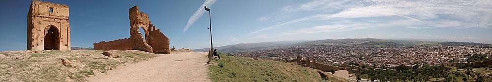
The Marinid Tombs or Merenid Tombs refer the ruins of monumental tombs on a hill above and north of Fes al-Bali, the old city of Fez, Morocco. Today, they are also a popular lookout point over the historic city.
Historical background
There is sparse information available on the site and its history. However, the ruined tombs are believed to date from the 14th century, during the Marinid dynasty (13th-15th centuries), hence their name.[1] The Marinids conquered Fez in 1250 (CE) and turned it into their capital, most notably building a new fortified palace city (Fes el-Jdid) in 1276 alongside the existing old city (Fes el-Bali). Starting in 1287, they also built a palace and a mosque on the hill just outside the city walls to the north, overlooking the heart of the old city.[2] This hill was known as al-Qula, and today simply as the "Hill of the Marinids".[1] Eventually, a royal necropolis was also constructed on the site.
Up until the middle of the 14th century the Marinid dynasty buried its members in the royal necropolis at Chellah, outside Rabat.[3] The sultan Abu Inan, however, was interred in the Grand mosque of Fes el-Jdid upon his death in 1358 and after this his successors were buried in the necropolis on the al-Qula hill. They continued to be interred here up until the demise of the dynasty.[3] (Only one of them was again buried at Chellah, which was otherwise abandoned.[3])
To this day, no rigorous archaeological excavations have yet been carried out on the site of the tombs.[3]
Description of the site
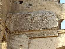
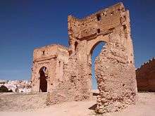
Today the ruins of two tall rectangular-base mausoleums with large horseshoe-arch entrances are still visible. It is not known exactly who was buried in these structures but given their monumentality they were probably members of the royal family. Some fragments of stucco decoration and inscription can still be seen on the walls of the mausoleums, which is all that remains of their once rich ornamentation. One chronicle (by Leo Africanus) mentions that the tombs featured lavish marble with colourful epitaphs.[1]
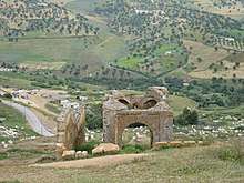
The site was probably once enclosed by a wall, giving it the form of a rawda, an enclosed funerary garden or private cemetery in the Islamic tradition.[3] Behind (or north of) the two mausoleums are also the ruins of another small domed building or qoubba that may have been part of the Merinid necropolis as well.[4] The hillsides around the tombs (mostly to the north and east) are still occupied by the sprawling Bab Guissa Cemetery (named after the nearby city gate, Bab Guissa)[5], though the graves visible today are likely much more recent.
Today the site is perhaps best known as a lookout with panoramic views over the old city of Fez, popular at sunset, and often mentioned in guidebooks and tourist literature.[6] In addition to the views, it is also a notable place to hear the call to prayer (adhan) broadcasting simultaneously from all the mosques in the old city.[7]
Notes
| Wikimedia Commons has media related to Marinid Tombs. |
- 1 2 3 Métalsi, Mohamed (2003). Fès: La ville essentielle. Paris: ACR Édition Internationale. pp. 8, 273. ISBN 978-2867701528.
- ↑ Gaudio, Attilio (1982). Fès: Joyau de la civilisation islamique. Paris: Les Presses de l'Unesco: Nouvelles Éditions Latines. pp. 115, 156. ISBN 2723301591.
- 1 2 3 4 5 Lintz, Yannick; Déléry, Claire; Tuil Leonetti, Bulle (2014). Maroc médiéval: Un empire de l'Afrique à l'Espagne. Paris: Louvre éditions. pp. 502, 514, 584. ISBN 9782350314907.
- ↑ "Nécropoles mérinides". À l'ombre du Zalagh, Madinat Fas (in French). 2017-11-26. Retrieved 2018-01-28.
- ↑ Le Tourneau, Roger (1949). Fès avant le protectorat: étude économique et sociale d'une ville de l'occident musulman. Casablanca: Société Marocaine de Librairie et d'Édition. pp. 110–111.
- ↑ "Historical Attraction of the Merenid Tombs - English Blog - By Morocco Channel". Retrieved 8 October 2016.
- ↑ Lonely Planet: Morocco (12th edition). Lonely Planet. 2017. pp. 294, 296. ISBN 9781786570321.
Coordinates: 34°4′11.16″N 4°58′45.27″W / 34.0697667°N 4.9792417°W