Marigny, Manche
| Marigny | |
|---|---|
 | |
 Marigny Location within Normandy region  Marigny | |
| Coordinates: 49°05′59″N 1°14′20″W / 49.0997°N 1.2389°WCoordinates: 49°05′59″N 1°14′20″W / 49.0997°N 1.2389°W | |
| Country | France |
| Region | Normandy |
| Department | Manche |
| Arrondissement | Saint-Lô |
| Canton | Saint-Lô-1 |
| Government | |
| • Mayor (2008–2014) | Bernard Brignot |
| Area1 | 10.31 km2 (3.98 sq mi) |
| Population (2006)2 | 2,067 |
| • Density | 200/km2 (520/sq mi) |
| Time zone | UTC+1 (CET) |
| • Summer (DST) | UTC+2 (CEST) |
| INSEE/Postal code | 50292 /50570 |
| Elevation | 32–112 m (105–367 ft) |
|
1 French Land Register data, which excludes lakes, ponds, glaciers > 1 km2 (0.386 sq mi or 247 acres) and river estuaries. 2 Population without double counting: residents of multiple communes (e.g., students and military personnel) only counted once. | |
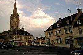
Marigny is a former commune in the Manche department in Normandy in north-western France. On 1 January 2016, it was merged into the new commune of Marigny-le-Lozon.[1]
Heraldry
 |
The arms of Marigny are blazoned : Azure, a chevron between 2 roses and a lion Or. |
See also
References
- ↑ Arrêté préfectoral 15 December 2015 (in French)
| Wikimedia Commons has media related to Marigny, Manche. |
| Authority control |
|---|
This article is issued from
Wikipedia.
The text is licensed under Creative Commons - Attribution - Sharealike.
Additional terms may apply for the media files.