Marie Tharp
| Marie Tharp | |
|---|---|
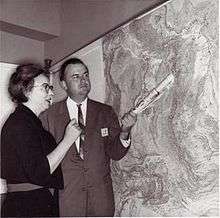 Tharp and Heezen | |
| Born |
July 30, 1920 Ypsilanti, Michigan |
| Died |
August 23, 2006 (aged 86) Nyack, New York |
| Residence | United States |
| Nationality | United States |
| Citizenship | United States |
| Alma mater |
Ohio University University of Michigan University of Tulsa |
| Known for | Seafloor topography |
| Scientific career | |
| Fields | Geology, Oceanography |
| Institutions | Lamont-Doherty Earth Observatory |
Marie Tharp (July 30, 1920 – August 23, 2006) was an American geologist and oceanographic cartographer who, in partnership with Bruce Heezen, created the first scientific map of the Atlantic Ocean floor. Tharp's work revealed the presence of the Mid-Atlantic Ridge, causing a paradigm shift in earth science that led to acceptance of the theories of plate tectonics and continental drift.[1]
Early life
Tharp was born in Ypsilanti, Michigan. Her mother, Bertha, was an instructor in German and Latin; her father, William, made soil classification maps for the U.S. Department of Agriculture. She had one much older half sibling, but was raised more or less as an only child.[2]
Tharp graduated from Ohio University in 1943 with bachelor's degrees in English and music and four minors. World War II meant more women were being recruited into professions like petroleum geology, hitherto male-dominated, and, having taken a geology class at Ohio, she was recruited to the University of Michigan at Ann Arbor's petroleum geology program, where she completed a master's degree.[2] Tharp's leap into a career in earth sciences is extraordinary given the few women in this field — women obtained fewer than 4% of all earth sciences doctorates at this time.[3] She took a job at Standard Oil and Gas in Tulsa, but found it unsatisfying, earning a BS in mathematics from the University of Tulsa while working as a geologist for the Stanolind Oil company.[4]
Career
Moving to New York in 1948, Tharp was employed by Maurice Ewing at the Lamont Geological Laboratory (now the Lamont-Doherty Earth Observatory) at Columbia University, initially as a general drafter.[4] There, Tharp met Bruce Heezen, and in early work together they used photographic data to locate downed aircraft from World War II.[5] Tharp was employed and continuously promoted from 1952 to 1968, when her position was cut and moved to grant-funded status due to lab politics involving Heezen (she remained in a grant-funded position until Heezen's death in 1977). Later, they began working together to map the topography of the ocean floor. For the first 18 years of their collaboration, Heezen collected bathymetric data aboard the research ship, the Vema, while Tharp drew maps from that data since women were still excluded from working aboard ship at that time. Although restricted from conducting research at sea early in her career due to her gender, she was later able to join a 1965 data-collection expedition. Tharp independently used data collected from the Woods Hole Oceanographic Institution's research ship Atlantis, and seismographic data from undersea earthquakes. Her work with Heezen represented the first systematic attempt to map the entire ocean floor.
In 1952, Tharp first identified the Mid-Atlantic rift. Heezen was initially unconvinced as the idea would have supported continental drift, then a controversial theory. Instead, for a time he favored the expanding Earth hypothesis,[6][7] ridiculing her theory as "girl talk". However, under Tharp's direction, Heezen eventually turned to the alternative theories of plate tectonics and continental drift,[8] and they published their first physiographic map of the North Atlantic in 1957. Nonetheless, Tharp's name does not appear on any of the major papers on plate tectonics that he and others published between 1959 and 1963. Subsequently, in collaboration with the Austrian landscape painter Heinrich Berann, they published their map of the entire ocean floor in 1977 (coincidentally, also the year of Heezen's death).
After Heezen's death, Tharp continued to serve on the faculty of Columbia University until 1983, after which she operated a map-distribution business in South Nyack during her retirement. Tharp donated her map collection and notes to the Map and Geography Division of the Library of Congress in 1995.[9] In 1997, Tharp received double honors from the Library of Congress, which named her one of the four greatest cartographers of the 20th century and included her work in an exhibit in the 100th-anniversary celebration of its Geography and Map Division.[10] In 2001, Tharp was awarded the first annual Lamont-Doherty Heritage Award at her home institution for her life's work as a pioneer of oceanography.[1]
Tharp died of cancer in Nyack, New York on August 23, 2006.[11]
Posthumous recognition
In 2009, Google Earth included the Marie Tharp Historical Map layer, to allow people to view Tharp's ocean map using the Google Earth interface.[12]
In 2013, author Hali Felt published a biography of Marie Tharp entitled Soundings: The Story of the Remarkable Woman Who Mapped the Ocean Floor.[13] It was cited by the New York Times for its standing as an "eloquent testament both to Tharp's importance and to Felt's powers of imagination."[14]
Marie Tharp Fellowship
The Marie Tharp Fellowship is a competitive academic visiting fellowship awarded to women to work with researchers at Columbia University's Earth Institute.[15][16]
Journal articles
- Heezen, B C; Bunce, Elizabeth T; Hersey, J B; Tharp, Marie (1964). "Chain and Romanche fracture zones". Deep-Sea Research and Oceanographic Abstracts. 11 (1): 11–33. Bibcode:1964DSROA..11...11H. doi:10.1016/0011-7471(64)91079-4.
- Heezen, B C; Tharp, Marie (1965). "Tectonic fabric of the atlantic and indian oceans and continental drift". Philosophical Transactions of the Royal Society of London A. 258 (1088): 90–106. Bibcode:1965RSPTA.258...90H. doi:10.1098/rsta.1965.0024.
- Tharp, Marie; Friedman, Gerald M (2002). "Mapping the world ocean floor". Northeastern Geology and Environmental Sciences. 24 (2): 142–149. .
References
- 1 2 Lamont-Doherty Earth Observatory Bestows Heritage Award on Marie Tharp, Pioneer of Modern Oceanography, Published Jul 10, 2001, Retrieved Oct 12, 2014
- 1 2 Barton, Cathy (2002). "Marie Tharp, oceanographic cartographer, and her contributions to the revolution in the Earth sciences". Geological Society, London, Special Publications. 192 (1): 215–228. Bibcode:2002GSLSP.192..215B. doi:10.1144/gsl.sp.2002.192.01.11.
- ↑ Blakemore, Erin (2016-08-30). "Seeing Is Believing: How Marie Tharp Changed Geology Forever". Smithsonian.
- 1 2 Tharp, M. (2006-12-12). "Marie Tharp biography". Woods Hole Oceanographic Institution. Retrieved 2008-06-02.
- ↑ Evans, R. (November 2002). "Plumbing Depths to Reach New Heights". Retrieved 2008-06-02.
- ↑ Barton, C. (2002). "Marie Tharp, oceanographic cartographer, and her contributions to the revolution in the Earth sciences". Geological Society, London, Special Publications. 192 (1): 215–228. Bibcode:2002GSLSP.192..215B. doi:10.1144/GSL.SP.2002.192.01.11.
- ↑ Doel, R.E.; Levin, T.J.; Marker, M.K. (2006). "Extending modern cartography to the ocean depths: military patronage, Cold War priorities, and the Heezen-Tharp mapping project, 1952–1959". Journal of Historical Geography. 32 (3): 605–626. doi:10.1016/j.jhg.2005.10.011.
- ↑ Wills, Matthew (2016-10-08). "The Mother of Ocean Floor Cartography". JSTOR. Retrieved 2016-10-14.
While working with the North Atlantic data, she noted what must have been a rift between high undersea mountains. This suggested earthquake activity, which then [was] only associated with [the] fringe theory of continental drift. Heezen infamously dismissed his assistant's idea as "girl talk." But she was right, and her thinking helped to vindicate Alfred Wegener's 1912 theory of moving continents. Yet Tharp's name isn't on any of the key papers that Heezen and others published about plate tectonics between 1959–1963, which brought this once-controversial idea to the mainstream of earth sciences.
- ↑ "Primary Sources in Science Classrooms: Mapping the Ocean Floor, Marie Tharp, and Making Arguments from Evidence (Part 1) | Teaching with the Library of Congress". blogs.loc.gov. 2015-10-08. Retrieved 2015-10-29.
- ↑ Jarvis, Brooke (2014-12-09). "How One Woman's Discovery Shook the Foundations of Geology". mentalfloss.com.
- ↑ Fox, Margalit (August 26, 2006). "Marie Tharp, Oceanographic Cartographer, Dies at 86". New York Times. Retrieved April 9, 2012.
- ↑ Google Earth drops into the oceans, Guardian News, 2 February 2009, Retrieved Oct 12, 2014
- ↑ Macmillan Publishers: Hali Felt, Retrieved Oct 12, 2014
- ↑ Floating Ideas: ‘Soundings,’ About Marie Tharp, by Hali Felt, New York Times, 25 January 2013, Retrieved Oct 12, 2014
- ↑ "Marie Tharp Fellowship Information" (PDF). earth.columbia.edu. Columbia University. 2013.
- ↑ "The Marie Tharp Fellowship". earth.columbia.edu. The Earth Institute, Columbia University. Retrieved 2016-08-22.
Further reading
- C250 Celebrates 250 Columbians Ahead of Their Time: Entry on Marie Tharp.
- Woods Hole Oceeanographic Institution. "Marie Tharp Honored at Women Pioneers Seminar."
- The Earth Institute at Columbia University. "Mapping Methodology Examples (North Atlantic)."
- The Earth Institute at Columbia University. "Marie Tharp, Pioneering Mapmaker of the Ocean Floor, Dies." Earth Institute News, August 23, 2006.
- Nelson, Valerie. "Marie Tharp, 86; Pioneering Maps Altered Views on Seafloor Geology." The Los Angeles Times, September 4, 2006.
- Hall, Stephen S. "The Contrary Map Maker" The New York Times Magazine, December 31, 2006.
- Felt, Hali (2012). Soundings: The Story of the Remarkable Woman Who Mapped the Ocean Floor. New York: Henry Holt and Co. ISBN 9780805092158.
- Doel, Ronald (1970–80). "Tharp, Marie". Dictionary of Scientific Biography. 25. New York: Charles Scribner's Sons. pp. 29–31. ISBN 978-0-684-10114-9.
External links
| Library resources about Marie Tharp |
| By Marie Tharp |
|---|
| Authority control |
|---|