Mariazell Airport
| Mariazell Airport Flugplatz Mariazell | |||||||||||||||
|---|---|---|---|---|---|---|---|---|---|---|---|---|---|---|---|
 | |||||||||||||||
| Summary | |||||||||||||||
| Airport type | Private | ||||||||||||||
| Serves | Mariazell | ||||||||||||||
| Location | Austria | ||||||||||||||
| Elevation AMSL | 2,828 ft / 862 m | ||||||||||||||
| Coordinates | 47°47′23.4″N 015°18′0.7″E / 47.789833°N 15.300194°ECoordinates: 47°47′23.4″N 015°18′0.7″E / 47.789833°N 15.300194°E | ||||||||||||||
| Map | |||||||||||||||
 LOGM Location of Mariazell Airport in Austria | |||||||||||||||
| Runways | |||||||||||||||
| |||||||||||||||
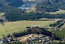
Mariazell Airport (German: Flugplatz Mariazell, ICAO: LOGM) is a private use airport located 2 kilometres (1 mi) north-northwest of Mariazell, Steiermark, Austria.
See also
References
- ↑ Airport record for Mariazell Airport at Landings.com. Retrieved 2013-09-01
- ↑ Google (2013-09-01). "location of Mariazell Airport" (Map). Google Maps. Google. Retrieved 2013-09-01.
External links

- Airport record for Mariazell Airport at Landings.com
This article is issued from
Wikipedia.
The text is licensed under Creative Commons - Attribution - Sharealike.
Additional terms may apply for the media files.