Mardale
Coordinates: 54°30′36″N 2°48′36″W / 54.510°N 2.810°W
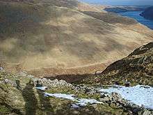
Mardale /mɑːrdeɪl/ is a glacial valley in the Lake District, in northern England. The valley used to have a hamlet at its head, called Mardale Green, but this village was submerged in the late 1930s when the water level of the valley's lake, Haweswater, was raised to form Haweswater Reservoir by Manchester Corporation.[1][2]
Most of the village's buildings were blown up by the Royal Engineers, who used them for demolition practice. The exception was the small church, which could accommodate only 75 people, and had an all-ticket congregation for its last service. It was then dismantled in April 1937, stone by stone, and the stones and windows were re-used to build the water take-off tower which is situated along the Western shore of the reservoir.[3] Some 97 sets of remains were disinterred from the churchyard and transferred to Shap.[3] Alfred Wainwright protested bitterly about the loss of Mardale in his series of pictorial guides to the Lakeland fells, having first visited it in 1930. The ruins of the abandoned village occasionally reappear when the water level in the reservoir is low.[1][2][3]
In response to the submerging of the village, Manchester Corporation provided a new access road that runs for four miles along the south-eastern side of the reservoir to a car park at Gatescarth. From here ascents of the peaks surrounding the head of the valley, such as Harter Fell, High Street and Kidsty Pike may be made.
References
- 1 2 The "lost village" of Mardale, BBC, November 2003. Retrieved 2013-01-01.
- 1 2 Emergency water measures planned, BBC news website, 2003-11-11. Retrieved 2013-01-01.
- 1 2 3 The "lost village" of Mardale, BBC news website. 2010-07-15. Retrieved 2013-01-01.
| Wikimedia Commons has media related to Mardale. |