Marcel van den Broecke
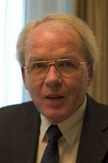
Marcel Peter René van den Broecke (born 25 May 1942) is a Dutch specialist in phonetics and cartography, and more particularly the historical maps of Abraham Ortelius.
Studies
Born in Amsterdam, Van den Broecke attended the Barlaeus grammar school there, studied chemistry for one year at Brandeis University, Waltham, Mass., and further studied English, linguistics and phonetics at the University of Amsterdam. He published his doctorate, Hierarchies and Rank Orders in Distinctive Features 1976, Van Gorcum, Assen, 196 pp, with honours, at the Utrecht University.
In 1982/1983 he studied cartography, under the direction of Guenther Schilder at Utrecht University. He acquired another Ph.D. In 2009 he published that thesis, Ortelius' Theatrum Orbis Terrarum (1570–1641) Characteristics and development of a sample of on verso texts (NGS 380, Utrecht, 304 pp. + CD-ROM).
Professional activities
Van den Broecke taught English and Phonetics at Utrecht University as assistant professor. Among his other academic activities, he was secretary-general at the 10th International Congress of Phonetic Sciences in Utrecht in 1983, and edited the preprints and proceedings of this Congress (Foris, Dordrecht). He edited Sound Structures, studies presented to Antonie Cohen, (Foris, Dordrecht, 1983, 318 pp.) and wrote an article in this book about his reconstruction of the first speaking machine by Wolfgang von Kempelen (1790).
He was editor of the periodical Progress Report of the Institute of Phonetics at Utrecht university (PRIPU), 1977–1988, and editor of Journal of Phonetics, Academic Press London, 1985–1990.
He compiled and edited the book Ter Sprake. Spraak als betekenisvol geluid in 36 hoofdstukken, Foris, 1988, with two reprints in the same year.[1]
He has also been director of the Foundation for Public Understanding of Science (PWT), 1988–1995, of the Dutch Humanist League, 1995–1997, and of the International Statistical Institute, the Hague. (1997-2003)
He is married to Deborah Günzburger and has four sons: Duco, Bas, Sebastiaan and Michiel.
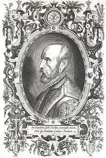
Abraham Ortelius
From 1983 on Marcel van den Broecke studied historical maps and specialized in the life and work of the cartographer Abraham Ortelius (1527–1598).
In 1996 he published Ortelius Atlas Maps, (HeS uitgeverij, Houten, 307 pp.), with an extended second edition in 2009.
In 1998 he wrote together with Peter van der Krogt and Peter Meurer Abraham Ortelius and the first atlas. Essays commemorating the Quadricentennial of his Death, 1598–1998 (HeS uitgeverij), with also articles by himself.[2]>
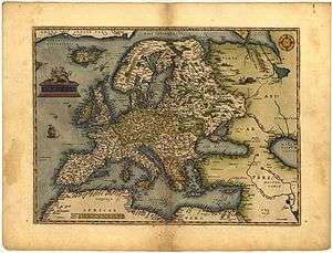
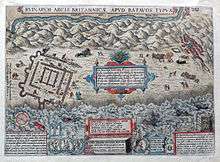
Ortelius was the first cartographer who assembled a world atlas in 1570 which he published himself. The combination of devising cartographical images by combining different sources for this purpose, or alternatively by mentioning his source by name, to write texts which would be printed on the back side of the map, to have these printed and to be his own publisher and bookseller, was unique at this time and brought him wealth. Ortelius was a close friend of the also Flemish cartographer Gerard Mercator who was half a generation older. Ortelius greatly admired Mercator for his qualities as a mathematician, designer of a new projection method to represent a globe on a flat surface, and for his qualities as an engraver and as surveyor.
In turn Mercator respected Ortelius for his knowledge of classical Greek and Roman literature, for his enormous linguistic and language knowledge, having mastered next to his native languages of French and Dutch by self-study also Greek, Latin, Italian, Spanish, Portuguese and German. When Ortelius decided to become his own publisher for his atlases, this brought him wealth, whereas Mercator had life-long diffeculties to make ends meet, but Ortelius and Mercator also deeply respected one another for the knowledge and talents of the other. No wonder that the Dutch atlas maker Willem Blaeu in 1635 gave his atlas their names, Mercator and Ortelius, as the best examples he knew.
Publications
Phonetics
- Ter Sprake. Spraak als betekenisvol geluid in 36 thematische hoofdstukken (red.), Foris Publications, Dordrecht, 471 pp., 1988. Drie herdrukken in hetzelfde jaar.
Ortelius
Source:[3]
- How rare is a map and the atlas it comes from? Facts and speculations on production and survival of Ortelius' Theatrum Orbis Terrarum and its maps, in: The Map Collector, 1986, 36: 2–15.
- Variaties binnen edities van oude atlassen, geïllustreerd aan Ortelius' Theatrum Orbis Terrarum, in: Caert Thresoor, 1994, 13 (4): 103–110.
- Unstable editions of Ortelius' atlas, in: The Map Collector, 1995, 70: 2–8.
- Ortelius zag de continenten al drijven, in: Caert-Thresoor, 1995, 14: 9–10.
- Ortelius Atlas Maps: an illustrated guide HES Publishers, 1996, 312 pp.[4]
- Platen en staten in Ortelius' Theatrum Orbis Terrarum, in: Capita Selecta uit de geschiedenis van de kartografie, ed. P. van der Krogt. NVK publikatiereeks nr. 18, Amersfoort, Nederlandse Vereniging voor Kartografie, pp. 39–42
- Abraham Ortelius Mercators World, 1997, 2(3): 18–24
- Introduction to the Life and Works of Abraham Ortelius, in: Abraham Ortelius and the First Atlas, M.P.R. van den Broecke, P. van der Krogt & P.H. Meurer, eds., 't Goy-Houten, HES Publishers, 1998, pp. 29–54
- The Plates of Ortelius' Theatrum Orbis Terrarum, in: Abraham Ortelius and the First Atlas, Marcel van den Broecke, Peter van der Krogt & Peter H. Meurer, eds., 't Goy-Houten, HES Publishers, 1998, pp. 383–390
- Unmasking a Forgery, Mercators World, 1998 3(3): 46–49
- Abraham Ortelius, grondlegger van de moderne kartografie, in: Kartografisch Tijdschrift, 1998, 24: 4–8
- Ortelius as a Scientist, Collector and Merchant, in: Journal of the International Map Collector's Society (Imcos) 1998, 77: 21–31,
- Historical Maps in the First Modern Atlas by Abraham Ortelius: Their Justification and Purpose, exemplified by their texts, Brussels International Map Collector Society (BIMCS), February 2002, p. 12–16 & 20–35.
- Historische kaarten en hun teksten in de eerste moderne atlas van Abraham Ortelius, in: Caert-Thresoor, 2002, 22(2): 29–39, with an English summary.
- Correcties op het boek Ortelius Atlas Maps, in: Caert-Thresoor, 2003 22(2): 60–61.
- De eerste staat van Vrients/Philip Galle's Inferioris Germaniae kaart gevonden, in: Caert-Thresoor, 2004, 23(1): 1–4
- De Utopia kaart van Ortelius, in: Caert-Thresoor, 2004, 22(4): 89–93.
- Has the fourth Ortelius Americas plate ever been used?, in: Mapforum, 2005, 7:28–32.
- Oceanography in Ortelius's atlas text, in: International Journal on the history of Oceanography, 2005, issue 17, p. 4–9.
- Unmasking another Ortelius atlas map forgery: Iceland, in: IMCOS Journal, 2006 issue 106, pp. 7–9.
- Ortelius' Zeeland kaart revisited, in: Caert-Thresoor, 2007, 26: 16.
- The significance of language: The Texts on the Verso of the Maps in Abraham Ortelius' Theatrum Orbis Terrarum, Imago Mundi Vol. 60 Part 2: 2008, 202–210.
- Ortelius' Theatrum Orbis Terrarum (1570–1641): Characteristics and development of a sample of on verso texts, in Netherlands Geographical Studies 380, ISSN 0169-4839, ISBN 978-90-6809-423-7 KNAG The Hague, 304 pp.
- Ortelius' Epitomes?, in: Caert-Thresoor, 2011, 30(2): 47–51
- Ortelius Atlas Maps, An illustrated guide, Second revised edition, 't Goy-Houten HES Publishers, 2011, 708 pp.
- Ortelius' Brittenburg, in: Caert-Thresoor, 2011, 32: 42–46.
- Ortelius’ Engravers and Engravings. How many engravers did Ortelius employ for his maps, and how can they be identified?, in: Imcos Journal 134, Autumn 2013, p. 29-37.
- Ortelius’ Library Reconstructed, in Imago Mundi, 2014, 66.1: 25-50
- Ortelius’ Merchandise: His Atlases, Then and Now, in The Portolan, 2014, 90: 8-33
- Mercator and Ortelius, two of a kind?, in: A world of innovation, Cartography in the Time of Gerhard Mercator, edited by Gerhard Holzer, Valery Newby, Petra Svatek and Georg Zotti, Cambridge Scholars Publishing (2015), chapter 9, p. 160-180.
- Abraham Ortelius, 1527-1598. His life, works, sources and friends, published by himself, 2015, 379 pp, 2.3 kg, + DVD with Album Amicorem, Deorum Deormque Capita, Itinerarium, and Sources and Friends. Available on Cartographica Neerlandica
- (with Deborah Günzburger), "The Wanderings of patriarch Abraham", in: Abraham Ortelius and the First Atlas, Marcel van den Broecke, Peter van der Krogt & Peter H. Meurer, eds., 't Goy-Houten, HES Publishers, 1998, pp. 319–330
- (with Peter van der Krogt & Peter H. Meurer, eds.) Abraham Ortelius and the First Atlas, 't Goy-Houten, HES Publishers, 1998, 430 pp.
- (with Ferjan Ormeling), What's in a Name (topographical names on Ortelius' Utopia map), in: The Map Book, Peter Barber (ed.) p. 132–133, Weidenfeld & Nicolson, London, UK, 2005.
References
- ↑ Information on professional activities on Linkedin
- ↑ Book reviews : John Barret, in: Newsletter Brussel International Map Collectors Circle, 1999; Hans-Uli Feldman, in: Cartographica Helvetica, 1999; Jason Harris, in: Imago Mundi, 2000
- ↑ An overview of reference reviews.
- ↑ Book reviews on Ortelius Atlas Maps, an illustrated guide
- Wulf BODENSTEIN, in: Brussels International Map Collectors Circle, Jan. 2012
- Fredric SHANGER, in: The Portolan, 2012
- Lisette DANCKAERT, in: Caert-Tresoor, 2012
- Hans-Uli FELDMANN, in: Cartografica Helvetica, 2012
- Peter BARBER, in: The Book Collector, 2012
- Alfred Hiatt, in: IMCoS Journal, 2012
External links
| Authority control |
|---|