Marble Mountain-Trout Creek Hill
| Marble Mountain-Trout Creek Hill | |
|---|---|
 West Crater with associated lava flows | |
| Highest point | |
| Elevation | 492 to 4,521 ft (150 to 1,378 m)[1] |
| Coordinates | 45°54′N 122°00′W / 45.9°N 122.0°WCoordinates: 45°54′N 122°00′W / 45.9°N 122.0°W [1] |
| Geography | |
| Location |
Skamania County, Washington, United States |
| Parent range | Cascade Range[2] |
| Topo map | USGS Bare Mountain |
| Geology | |
| Age of rock | less than 700,000 years[1] |
| Mountain type | Volcanic field[3] |
| Volcanic arc/belt | Cascade Volcanic Arc[2] |
| Last eruption | ~7,700 years BP[1] |
Marble Mountain-Trout Creek Hill volcanic field (MMTC) is a volcanic field located in Washington, US.
Notable Vents
| Name | Elevation | Coordinates | Last eruption |
| Bare Mountain[1] | |||
| Marble Mountain[1] | 4,127 ft (1,258 m) | ||
| Trout Creek Hill[3] | 2,930 ft (893 m) | 45°49′N 122°00′W / 45.817°N 122.000°W | ~340,000 years ago |
| West Crater[1][3] | 4,360 ft (1,329 m) | 45°53′N 122°05′W / 45.88°N 122.08°W | 5750 BC? |
Trout Creek Hill
Trout Creek Hill is a small Pleistocene basaltic shield volcano in Washington, United States. It produced a lava flow about 340,000 years ago that traveled 20 km (12 mi) southeast, which dammed the Columbia River for a short period of time.[3]
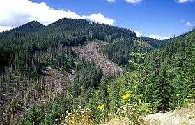
West Crater
West Crater is a small andesitic lava dome with associated lava flows in southern Washington.[3]
See also
References
- 1 2 3 4 5 6 7 Wood, Charles A.; Jűrgen Kienle (1993). Volcanoes of North America. Cambridge University Press. pp. 167–168. ISBN 0-521-43811-X.
- 1 2 "West Crater | Photo". Global Volcanism Program. Smithsonian Institution. Retrieved 2009-01-15.
- 1 2 3 4 5 "West Crater". Global Volcanism Program. Smithsonian Institution. Retrieved 2007-05-13.
This article is issued from
Wikipedia.
The text is licensed under Creative Commons - Attribution - Sharealike.
Additional terms may apply for the media files.