Manto Sipi Cree Nation
| God's River | |
|---|---|
| Indian reserve | |
| Nickname(s): Manto Sipi Cree Nation | |
 God's River Location of God's Lake in Manitoba | |
| Coordinates: 54°50′11″N 94°03′23″W / 54.83639°N 94.05639°WCoordinates: 54°50′11″N 94°03′23″W / 54.83639°N 94.05639°W | |
| Country | Canada |
| Province | Manitoba |
| Region | Northern |
| Government | |
| • MP (Churchill—Keewatinook Aski) | Niki Ashton (NDP) |
| • MLA (Kewatinook) | Judy Klassen (Lib) |
| Area | |
| • Total | 4.01 km2 (1.55 sq mi) |
| Elevation | 170 m (560 ft) |
| Population (2016[1]) | |
| • Total | 643 |
| • Density | 160.2/km2 (415/sq mi) |
| Time zone | UTC-6 (CST) |
| • Summer (DST) | UTC-5 (CDT) |
Gods River is a remote, isolated settlement in Northern Manitoba, Canada and the primary settlement of the Manto Sipi Cree Nation (54°50′15″N 94°03′17″W / 54.83750°N 94.05472°W) First Nations community. The settlement is on Gods Lake at the point of outflow of the Gods River.
The community can only be reached by winter road or by air via Gods Lake Airport.
The official languages of the community are English and Cree. There is a lodge for tourists to stay for visits to the community.
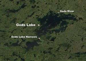 Gods River on Gods Lake |
External links
References
- "Gods River". Geographical Names Data Base. Natural Resources Canada. Retrieved 2011-03-01.
- "Gods River". Atlas of Canada. Natural Resources Canada. 2010-02-04. Retrieved 2011-03-01.
- ↑ "God's River Census Canada data". Census Canada. Retrieved 2018-06-20.
| Cities |  | |
|---|---|---|
| Local government districts | ||
| First Nations | ||
| Indian reserves | ||
| Indian settlements | ||
| Unorganized areas | ||
| Unincorporated communities | ||
This article is issued from
Wikipedia.
The text is licensed under Creative Commons - Attribution - Sharealike.
Additional terms may apply for the media files.