Mansell Street
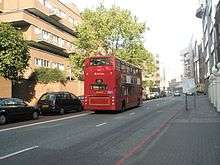 Bus heading northwards up Mansell Street | |
| Location | City of London, Tower Hamlets, London |
|---|---|
| Postal code | E1 |
| Nearest Tube station |
|
| Coordinates | 51°30′52.1″N 0°4′26.12″W / 51.514472°N 0.0739222°WCoordinates: 51°30′52.1″N 0°4′26.12″W / 51.514472°N 0.0739222°W |
| North end | Aldgate |
| South end | East Smithfield |
| Construction | |
| Construction start | 17th Century |
| Completion | 17th Century |
Mansell Street is a street in East London, which is part of the London Inner Ring Road. For most of its length from the north, this street marks the boundary between the City of London and the London Borough of Tower Hamlets. However. the southernmost part is entirely in Tower Hamlets.
History
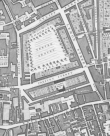
Detail from John Rocque's Map of London, 1746
Mansell Street was named after a relative of William Leman, whose great-uncle, John Leman had bought Goodman's Fields earlier in the seventeenth century.[1] Alie Street ran along the western side, with Leman Street to the east, Prescot Street to the south, and Alie Street to the North. These new streets were developed in the late seventeenth century while Goodman's Fields was used as a tenterground.[2]
Mansell Street estate
This estate was built in 1977 by the Guinness Trust.[3]
References
- ↑ "Alie Street Blog Post – July 2015". www.rcpath.org. Royal College of Pathologists. Retrieved 19 March 2017.
- ↑ "Archaeology at 31-33 Prescot Street & 99 Mansell Street" (PDF). marldon.net. Marldon. Retrieved 19 March 2017.
- ↑ "Mansell Street, City of London - The Guinness Partnership". The Guinness Partnership. Retrieved 20 March 2017.
This article is issued from
Wikipedia.
The text is licensed under Creative Commons - Attribution - Sharealike.
Additional terms may apply for the media files.