Mangkolemba
| Mangkolemba | |
|---|---|
| District | |
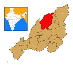 Mokokchung district's location in Nagaland | |
| Coordinates: 26°30′N 94°26′E / 26.500°N 94.433°ECoordinates: 26°30′N 94°26′E / 26.500°N 94.433°E | |
| Country | India |
| State | Nagaland |
| Seat | Mokokchung |
| Area | |
| • Total | 2 km2 (0.8 sq mi) |
| Population | |
| • Total | 6,000 |
| • Density | 3,000/km2 (7,800/sq mi) |
| Time zone | UTC+05:30 (IST) |
| ISO 3166 code | IN-NL-MK |
Mangkolemba is a town and sub-division of Mokokchung District in the Indian state of Nagaland. Bounded by rivers and mountains, it covers an area of about 2sq. km. The valley is noted for its rice production.[1]It has a population of about 6000 people and it has about 1300 households. The town is the sub-divisional HQ. of three ranges, namely, Changkikong, Japukong and Tsurangkong (covering about 40 villages).
References
- ↑ Coupe, Alexander Robertson (2007). A Grammar of Mongsen Ao. Walter de Gruyter. p. 8. ISBN 978-3-11-019088-5.
This article is issued from
Wikipedia.
The text is licensed under Creative Commons - Attribution - Sharealike.
Additional terms may apply for the media files.