Mangere Bridge, New Zealand
| Mangere Bridge | |
|---|---|
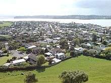 Western part of the suburb seen from Mangere Domain. | |
| Basic information | |
| Local authority | Auckland Council |
| Population | 5,547 (2006[1]) |
| Surrounds | |
| North | (Manukau Harbour) |
| Northeast | (Mangere Inlet) |
| East | Favona |
| Southeast | Favona |
| South | Mangere |
| Southwest | (Manukau Harbour) |
| West | (Manukau Harbour) |
| Northwest | (Manukau Harbour) |
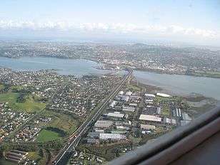
The Mangere Bridge suburb to the lower left, as well as the Mangere Bridge(s) in the background.
Mangere Bridge or Māngere Bridge is an Auckland suburb under the local governance of the Auckland Council, at the south end of Mangere's bridge over the Manukau Harbour.
It is home to Mangere Mountain and the Ambury Farm Park run by the Auckland Council, and backs onto rural land surrounding the Auckland Airport.[2]
It is a multicultural area, often with large families, with the suburb dominated by brick-and-tile homes built in the 1960s-1970s.[2]
Association Football
Mangere Bridge is home to Onehunga-Mangere United football club.
Notable Residents
- David Lange ONZ CH - Former Prime Minister
- Hon Willie Jackson - Politician, Broadcaster
- Jon Zealando - Magician
References
- ↑ Quickstats about Mangere Bridge
- 1 2 "Mangere - Property". The New Zealand Herald. 7 May 2005. Retrieved 7 February 2011.
External links
- Mangere Bridge community site
- Mangere Bridge Business Community site
- Photographs of Māngere Bridge held in Auckland Libraries' heritage collections.
Coordinates: 36°56′36″S 174°47′5″E / 36.94333°S 174.78472°E
This article is issued from
Wikipedia.
The text is licensed under Creative Commons - Attribution - Sharealike.
Additional terms may apply for the media files.