Mangart
| Mangart | |
|---|---|
| Mangrt | |
.jpg) Mangart | |
| Highest point | |
| Elevation | 2,679 m (8,789 ft) |
| Prominence | 1,065 m (3,494 ft) [1] |
| Isolation | 12.7 kilometres (7.9 mi) |
| Listing | Alpine mountains 2500-2999 m |
| Coordinates | 46°26′24″N 013°39′14″E / 46.44000°N 13.65389°ECoordinates: 46°26′24″N 013°39′14″E / 46.44000°N 13.65389°E |
| Geography | |
 Mangart Location in the Alps | |
| Location | Slovenia - Italy |
| Parent range | Julian Alps |
| Climbing | |
| First ascent | 1794 |
Mangart or Mangrt is a mountain in the Julian Alps, located on the border between Italy and Slovenia. With an elevation of 2,679 metres (8,789 ft), it is the third-highest peak in Slovenia, after Triglav and Škrlatica. It was first climbed in 1794 by the naturalist Franz von Hohenwart. Mangart is also the name of the mountain range between the Koritnica Valley and the Mangart Valley, with the highest peak called Veliki Mangart (Big Mount Mangart).
The road to Mangart Saddle (Slovene: Mangartsko sedlo; 2,072 metres or 6,798 feet) is the highest road in Slovenia.[2] The Mangart Pass Hut is located at the western foot of Mangart. There are two lakes under Mangart's northern face.
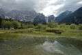 North face of Mangart, seen from the Lakes of Fusine, Italy
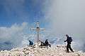 At the peak
 Mangart Saddle Lodge
References
- ↑ "Mangart - peakbagger". peakbagger.com. Retrieved 13 February 2015.
- ↑ Velkovrh, Ciril (2004). "Veliki vrhovi na zemljevidih Atlasa Slovenije" [Veliki Vrh on the Maps of the Atlas of Slovenia] (PDF). Geodetski vestnik (in Slovenian). Association of Geodesists. 48 (1): 108–110. ISSN 0351-0271.
External links
| Wikimedia Commons has media related to Mangart. |
This article is issued from
Wikipedia.
The text is licensed under Creative Commons - Attribution - Sharealike.
Additional terms may apply for the media files.