Mangapapa River (Bay of Plenty)
| Mangapapa River | |
|---|---|
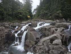 Mangapapa River at McLaren Falls, at the confluence with the Mangakarengorengo River | |
| Country | New Zealand |
| Physical characteristics | |
| Main source | Kaimai Range |
| River mouth |
Lake McLaren 81 m (266 ft) |
The Mangapapa River is a river of the Bay of Plenty Region of New Zealand's North Island. It rises on the north slopes of the Mamaku Plateau at the southern end of the Kaimai Range and meets the Opuiaki River at the head of Lake McLaren, which discharges to the Wairoa River a short distance downstream from the lake at the confluence with the Mangakarengorengo River.
The river has been modified as part of the Kaimai hydro power scheme. The 15.6 MW Lloyd Mandeno Power Station is on the left bank of the river and discharges water diverted from other nearby streams. About 4 kilometres (2.5 mi) below this is a concrete arch dam with the 6.25 MW Lower Mangapapa Power Station.[1]
See also
References
- "Place name detail: Mangapapa River (Bay of Plenty)". New Zealand Gazetteer. Land Information New Zealand. Retrieved 24 Jan 2010.
- New Zealand 1:50000 Topographic map sheet BD36 - Lower Kaimai
- ↑ "Kaimai scheme". Trustpower. Archived from the original on 2011-04-01. Retrieved 24 Jan 2011.
Coordinates: 37°49′24″S 176°2′20″E / 37.82333°S 176.03889°E
This article is issued from
Wikipedia.
The text is licensed under Creative Commons - Attribution - Sharealike.
Additional terms may apply for the media files.