Mandela, Rajasthan
Mandrella was established in the year 1751 by thakur Doulat Singh, son of Zorawar Singh of jhunjhunu. Mandrella is a town in the Jhunjhunu district of the state Rajasthan in India. The population size is about 30000.
Location
It is on the Jhunjhunu-Rajgarh road 25 km from Jhunjhunu and 95 km from Sikar. Its Coordinates are 27°56'42"N 74°55'31"E . The village lies about 25 km. north of the Jhunjhunu city and is also in close proximity with the town of Pilani.
Demographics
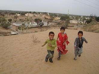
Population of the village is around 20000 mostly comprising two religions, Hindus and Muslims. There is remarkable level of religious harmony between the two religious groups and it is quite common that these two groups celebrate festivals with each other. The village boasts a Temple and a Mosque, representing a rich religious life.
Occupation
Villagers are mostly farmers but lately they are shifting to service and trade related occupations. A large segment of working people work in Arab countries and the village receives large remittances there.mostly the muslims. The decreasing reliance on agriculture and inflow of remittances has helped prosper the village.
Education
The village has two Government primary schools, a private upper primary school and a government senior secondary school. Apart than that the village have a CBSE affiliated private school KBM. Literacy rate is about 70% and is increasing rapidly due to rising awareness about education and its importance. And Mandela Have also Private college and School's(G.H. MEMORIAL PUB.SCH. MANDRELA) there is a rbse school pearls children Academy this is a brilliant school to students there all theachers are excellent but my(himanshu Saini) favorite is Mr shubham swami ji sir because he is best friend, as big bro, etc
Transport
The village is reachable by bus from nearby towns like Jhunjhunu, Pilani, Chirawa etc. and is connected well to the nearby places by means of privately owned busses. The village have a primary bus stand and a secondary one.
Climate
Here summers are hot and arid with temperatures reaching as high as 50 °C . In these times, sand storms and hot dry winds, called Loo, are common phenomena. In months of May and June, Loo becomes unbearable and may cause heatstroke. The place receives rainfall mostly in the months of July, August and September. Winters are severe and chilly with minimum temperature falling to 0 °C in January.
Geography
As the place is located in semi-desert region of the Thar, the landscape consists of sand dunes with scanty bushes. The main trees are Khejri, Neem, Peepal and Rohida.
Agriculture
Being in the semi-desert part of Rajasthan, the farming land cano grow crops which need less water. The crops grown are mainly pearl millet (Bajra), moong, moth, til and gawar. Famines occur frequently. The rabi crop is almost non-existent and irrigation is rarely used.
Places of Worship
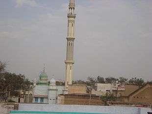
There are many temples like, Shakhambhari Temple, Hanuman Temple, Rani Sati Temple, Gillo Sati Temple, Shree Shyam Mandir, Bankia Balaji, Baba Baldevdas Bagichi etc. Jama Masjid and many mosques, which makes mandrella a religious place where both the hindu and muslim people are living together in peace.
Administration
Current Sarpanch - Rajkumar Singhal
MP Mrs Santosh Ahlawat