Mancos River
| Mancos River[1] | |
|---|---|
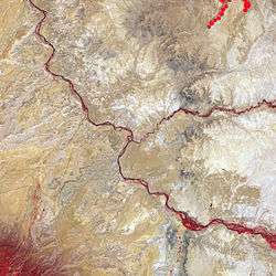 Mancos River, San Juan River confluence (Four Corners) (Carrizo Mountains at southwest) | |
| Physical characteristics | |
| Main source |
Confluence of West Mancos River and East Mancos River 37°21′30″N 108°15′12″W / 37.35833°N 108.25333°W |
| River mouth |
Confluence with San Juan 4,639 ft (1,414 m) 36°59′00″N 108°58′50″W / 36.98333°N 108.98056°WCoordinates: 36°59′00″N 108°58′50″W / 36.98333°N 108.98056°W |
| Basin features | |
| Progression | San Juan—Colorado |
The Mancos River, formerly also El Rio de San Lazaro, is an 85.4-mile-long (137.4 km)[2] northeast tributary of the San Juan River. It flows from the confluence of West Mancos River and East Mancos River near Mancos, Colorado and joins the San Juan near Four Corners Monument in New Mexico.[1]
The river was named after an incident during which a horse rider hurt his hand while crossing, the word Mancos being derived from Spanish meaning "one-armed".[3]
See also
References
- 1 2 "Mancos River". Geographic Names Information System. United States Geological Survey. Retrieved 2011-01-29.
- ↑ U.S. Geological Survey. National Hydrography Dataset high-resolution flowline data. The National Map Archived 2012-04-05 at WebCite, accessed March 21, 2011
- ↑ Dawson, John Frank. Place names in Colorado: why 700 communities were so named, 150 of Spanish or Indian origin. Denver, CO: The J. Frank Dawson Publishing Co. p. 33.
This article is issued from
Wikipedia.
The text is licensed under Creative Commons - Attribution - Sharealike.
Additional terms may apply for the media files.