Manchecourt
| Manchecourt | |
|---|---|
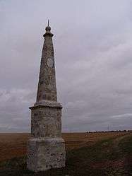 A Paris meridian marker in Manchecourt | |
 Manchecourt Location within Centre-Val de Loire region  Manchecourt | |
| Coordinates: 48°14′21″N 2°20′30″E / 48.2392°N 2.3417°ECoordinates: 48°14′21″N 2°20′30″E / 48.2392°N 2.3417°E | |
| Country | France |
| Region | Centre-Val de Loire |
| Department | Loiret |
| Arrondissement | Pithiviers |
| Canton | Malesherbes |
| Government | |
| • Mayor (2008–2014) | Thierry Catinat |
| Area1 | 16.23 km2 (6.27 sq mi) |
| Population (2006)2 | 632 |
| • Density | 39/km2 (100/sq mi) |
| Time zone | UTC+1 (CET) |
| • Summer (DST) | UTC+2 (CEST) |
| INSEE/Postal code | 45192 /45300 |
| Elevation | 107–138 m (351–453 ft) |
|
1 French Land Register data, which excludes lakes, ponds, glaciers > 1 km2 (0.386 sq mi or 247 acres) and river estuaries. 2 Population without double counting: residents of multiple communes (e.g., students and military personnel) only counted once. | |
Manchecourt is a former commune in the Loiret department in north-central France. On 1 January 2016, it was merged into the new commune of Le Malesherbois.[1]
See also
References
- ↑ Arrêté préfectoral 30 November 2015
| Wikimedia Commons has media related to Manchecourt. |
This article is issued from
Wikipedia.
The text is licensed under Creative Commons - Attribution - Sharealike.
Additional terms may apply for the media files.